A couple of windows this week, poor next

Western Australia Surf Forecast by Craig Brokensha (issued Monday August 8th)
Best Days: Perth and Mandurah Wednesday morning, Margs and Mandurah Thursday, Margs early Friday
Features of the Forecast (tl;dr)
- Large SW groundswell tomorrow with strong S/SW winds
- Easing mid-period SW tending S/SW swell Wed with gusty S/SW-S winds (SE-E/SE in Perth and Mandurah in the AM)
- Fading S/SW swell Thu with E/NE tending variable winds in the South West (E further north)
- Small, inconsistent SW swell Fri with fresh NE tending stronger N/NE winds
- Small Sat with strong but easing W/NW winds
- Building surf Sun with strengthening NW winds
Recap
A low point in swell on Saturday with lighter winds across all locations though small in the South West and better across Mandurah to 1-2ft. Perth was tiny and to 1-1.5ft.
Yesterday onshore winds created poor conditions with a new pulse of groundswell, larger today but windier with a mix of building windswell and mid-period energy.
This week and weekend (Aug 9 - 14)
Our strengthening onshore winds are associated with a strong mid-latitude low pushing in directly south-west of us, aiming a fetch of weakening S/SW gales through our south-western swell window.
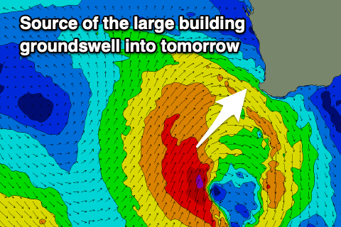 This will bring a large, SW groundswell for tomorrow with sets to 10ft+ across the South West, 4ft in Mandurah and 3-4ft across Perth.
Conditions will be a mess though with strong S/SW winds.
As touched on in Friday's notes, the slow movement of the low east through this week will result in poor, gusty S/SW-S winds persisting across the South West on Wednesday as the swell eases from a more S/SW direction, cleaner in Perth and Mandurah with a morning SE-E/SE breeze. Easing sets from 2-3ft are due across Mandurah, 2ft to occasionally 3ft in Perth.
Thursday still looks the cleanest with an E/NE offshore across the South West (E'ly further north) but with easing, weaker 3-5ft sets, 1-2ft in Mandurah and 1-1.5ft across Perth.
 Friday looks to remain small, but a reinforcing mid-period SW swell should maintain 3-4ft sets across Margs, tiny in Perth and Mandurah as winds tip NE, strengthening and then shifting more N/NE into the afternoon.
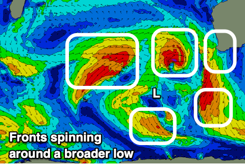
This will be ahead of our next run of onshore winds and large, stormy surf as a progression of strengthening polar turned mid-latitude fronts under a strengthening node of the Long Wave Trough.
We're due to see another broad low with multiple embedded fronts spinning around it, producing persistent onshore winds and building surf from Saturday through all of next week.
Perth and Mandurah should see windows of lighter winds but we'll take a closer look at this on Wednesday.