Fun surf late week

Western Australia Surf Forecast by Craig Brokensha (issued Monday January 31st)
Best Days: Exposed breaks for the keen tomorrow morning in the South West, Friday in the South West, Saturday morning in the South West, protected spots Monday, Tuesday morning
Features of the Forecast (tl;dr)
- Small mid-period S/SW swell tomorrow, easing through the day with strong E/SE tending S/SE-SE winds
- Inconsistent SW groundswell arriving late Thu, peaking Fri with fresh NE tending lighter N/NW winds
- Easing SW swell Sat with light E/NE-NE tending W winds
- Small mid-period SW swell Sun with strengthening SW winds
- Building mid-period W/SW-SW swell Mon with S/SE tending S/SW winds
- Easing swell Tue with E/SE tending S/SW winds
Recap
Friday afternoon's kick in new SW groundswell held well into Saturday morning with great conditions across the South West before deteriorating through the day. Perth and Mandurah were also clean but small and to 1-2ft.
Sunday was smaller and not as clean with less favourable winds out of the southern quadrant across all locations. This morning it's windier and smaller with limited options for a decent wave.
This weekend and next week (Jan 1 - 6)
The surf will continue on its downwards trend over the coming days, but there is one small, reinforcing S/SW swell due tomorrow morning, slowing the easing trend a touch. This was generated by a weak front over the weekend and should keep 3ft sets hitting the south swell magnets in the South West along with gusty E/SE winds, shifting S/SE-SE into the afternoon. There'll be no surf to the north.
 Wednesday and Thursday will be lay days with the swell bottoming out as winds shift more offshore from the E on the former, E/NE on the latter.
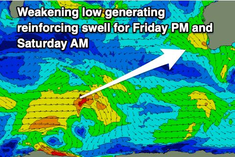
Later in the day Thursday our new, inconsistent SW groundswell is due, peaking through Friday, followed by a reinforcing pulse of swell through the day, easing Saturday.
These swells have and are still being generated by broad low that fired up to the south-east of South Africa, generating an initial strong burst of W/SW gales before weakening while moving east.
A weaker, trailing fetch of W/SW winds will generate the reinforcing pulse for Friday afternoon, easing Saturday.
Size wise, the South West should come in at inconsistent 4-5ft sets Friday, tiny in Perth and Mandurah, with Saturday easing from 3-5ft.
Friday morning will be clean across selected spots with a fresh NE breeze, tending lighter N/NW into the afternoon while Saturday morning should see early variable winds from the E/NE-NE ahead a weak W/SW change as a trough moves in from the west.
Sunday looks poor as the trough draws in stronger SW winds that will swing more S/SE into Monday.
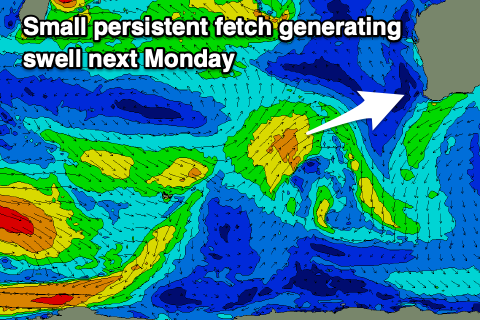 Swell wise a new pulse of small mid-period SW swell is due on Sunday but not to any major size, while a better pulse of W/SW-SW swell is due from the trough on Monday.
The source of this swell will be a small mid-latitude front moving in from the west-southwest later week, generating a fetch of persistent W/SW winds. It's nothing major but we should see a kick in size to the 6ft range in the South West, 2ft in Mandurah and 1-2ft in Perth.
Those S/SE winds will favour protected spots with Tuesday hopefully seeing winds improve further and swinging more E/SE.
Longer term the outlook remains slow with small mid-period swells due to continue and no significant swells at this stage. More on this Wednesday.