Fun weekend, large south swell for next week

Western Australia Surf Forecast by Craig Brokensha (issued Friday April 16th)
Best Days: Margs Saturday and further north into the afternoon, Margs Sunday morning (tiny Perth and Mandurah), Thursday, Friday morning in the South West
Features of the Forecast (tl;dr)
- Fun, mid-period W/SW swell building Sat with moderate E/NE winds and weak sea breezes, easing Sun with E/SE tending fresh SW winds
- Small, mid-period SW swell Mon with fresh S-S/SW winds
- Large S/SW groundswell for Thu with E'ly winds ahead of sea breezes
Recap
Easing surf but good conditions across both regions with 3-4ft waves in the South West yesterday, 3ft+ today while Perth and Mandurah dropped from 1-1.5ft+ yesterday, tiny today.
This weekend and next week (Apr 17 – 23)
Into the weekend we've got a fun pulse of mid-period W/SW on the cards, generated by a short-lived mid-latitude low the last couple of days.
The swell should build Saturday and peak into the afternoon to 4-5ft across the South West, 1-2ft in Mandurah and Perth late.
Winds look great with a moderate E/NE offshore tomorrow, giving into sea breezes early-mid afternoon but without too much strength. A light E/SE breeze is expected Sunday ahead of earlier sea breezes.
Monday will be a lay day with a drop in swell and change bringing a S/SW change on dawn if not shortly after.
A small lift in mid-period SW swell is due Monday from pre-frontal and unfavourably aligned W/NW gales developing late in our swell window but the size isn't expected to push over 3-4ft with similar sized waves Tuesday as winds swing back to the S/SE in the morning. Perth and Mandurah look cleaner but tiny.
Of greater importance is a large, long-period S/SW groundswell now due late week.
The source of this swell is quite interesting, that being a 'bombing' low.
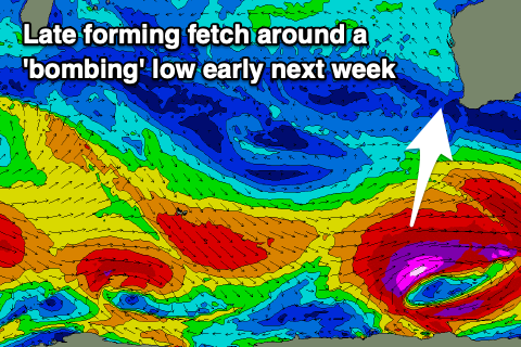 The catalyst will be a strong low that's forming off the South African coast today (south of Madagascar) forecast to track east on the weekend before being reabsorbed into the westerly storm track.
We'll see the low drop significantly in central pressure south-southwest of us, with a fetch of severe-gale to storm-force W/SW winds generated late in our southern swell window.
We should see a good kick in size for the South West when it fills in Thursday, offering 6-8ft sets across Margs, 2ft in Mandurah and 1-2ft across Perth.
With the storm some distance from us, conditions look great with a moderate E/SE offshore ahead of sea breezes, E/NE Friday as the swell eases.
Longer term, moderate sized pulses of swell are due into the weekend and next week, but more on this Monday. Have a great weekend!