Good swells for the weekend

Western Australia Surf Forecast by Craig Brokensha (issued Wednesday March 3rd)
Best Days: Protected spots Saturday afternoon, Sunday, Monday, Tuesday
Features of the Forecast (tl;dr)
- Weak, mid-period SW swell for Thu PM and Fri AM but with average north winds
- Small NW swell from TC Mariana Fri through Sun
- Good SW groundswell building Sat, peaking late in the day across the South West and Sun AM further north, with a secondary stronger swell Sun PM, easing slowly Mon
- SE winds Sun AM, E/SE Mon AM and E Tue AM
Recap
Nothing to really surf over the last day or so with the swell bottoming out across the state along with a bit of wet weather.
This week and weekend (Mar 4 - 7)
The end of the week will see a slight increase in background swell energy though winds look dicey.
Size wise we should see 3ft to possibly 4ft sets across the South West magnets later tomorrow and Friday morning. To the north some inconsistent NW swell is due from Tropical Cyclone Marian from Friday through Sunday but only to 2ft or so due to the limited swell generating fetch around Marian and the large distance from our coasts.
Conditions will be a touch wind affected tomorrow with a fresh though easing NE breeze (N/NE to the north), NW into the afternoon, while Friday should see N-N/NW tending SW winds. Not ideal.
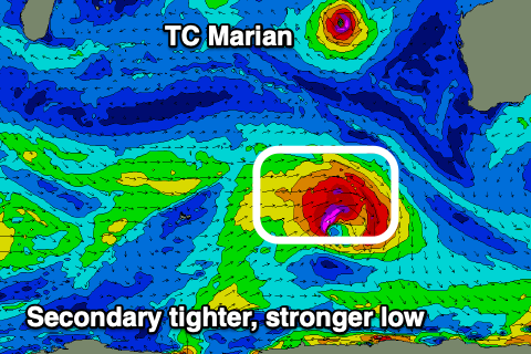
Moving into the weekend and our large, long-period SW groundswell is on track but we've got a secondary, stronger reinforcing pulse for Sunday afternoon.
The first swell for Saturday afternoon is being generated by a broad low that's currenrly moving across the Heard Island region, generating a fetch of W/SW gales. This system will weaken this evening and track away to the east-southeast while a secondary front fires up in its tail.
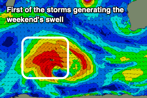 A smaller, tighter and stronger fetch of severe-gale to near storm-force W/SW winds will be generated, producing a slightly larger groundswell pulse for Sunday afternoon.
Size wise, Saturday's should build through the day and reach 6ft+ across the South West into the late afternoon with Perth and Mandurah seeing the size Sunday morning to 2ft+ and 2-3ft respectively.
Winds on Saturday morning aren't ideal and S/SE, giving into sea breezes while Sunday morning should see with a fresh SE winds, stronger from the S/SE into the afternoon in the South West with S/SW sea breezes to the north.
The stronger pulse of SW groundswell for Sunday afternoon looks to reach 8ft to occasionally 10ft on the swell magnets in the South West with Mandurah seeing more consistent 3ft surf, 2-3ft in Mandurah.
 We'll then see the swell easing Monday from 6ft to possibly 8ft, 2-3ft and 2ft+ respectively.
Winds should swing more E/SE Monday morning ahead of sea breezes, smaller again Tuesday with E'ly offshores.
Longer term we'll see a few late forming storms in our southern swell window producing surf late next week and into next weekend, but more on this Friday.