Only one decent surf day

Western Australia Surf Forecast by Craig Brokensha (issued Wednesday 9th December)
Best Days: Tomorrow (from mid-morning in the South West), Friday morning in the South West
Recap
Clean though small 2-3ft sets across the South West yesterday, tiny to the north.
Today there was a weak, wind affected windswell breaking across all locations with average winds, a lay day.
This week and weekend (Dec 8 - 13)
Currently a surface trough is squeezing a strong high to our west, bringing strong winds from the southern quadrant.
This will kick up a bit more size to the localised windswell tomorrow and a small low moving offshore should swing winds offshore.
There'll also be some inconsistent SW groundswell in the mix with the South West coming in around 3-5ft. Perth and Mandurah should see 2ft sets.
Looking at the winds and the South West will see strong SE winds at dawn, easing and swinging E'ly and then NE as the low pushes south. So aim for a surf mid-late morning onwards. Perth and Mandurah should see moderate to fresh E/NE tending N/NE winds, N/NW into the afternoon.
Friday then looks clean across all locations from the get go with a morning E/NE breeze, giving into afternoon W/SW sea breezes. Surf wise we'll be looking at the easing SW groundswell from 3-4ft in the South West, tiny and to 1ft to possibly 2ft north.
From the weekend through Monday, conditions look to deteriorate as a weak cold front edges in from the south-west, swinging winds S/SE Saturday morning and then S/SW into the afternoon with strength, holding Sunday from the SW but then reverting back to the S/SE on Monday.
This will spoil a small, new S/SW groundswell due Saturday, but the low linked to this swell now looks poor in structure.
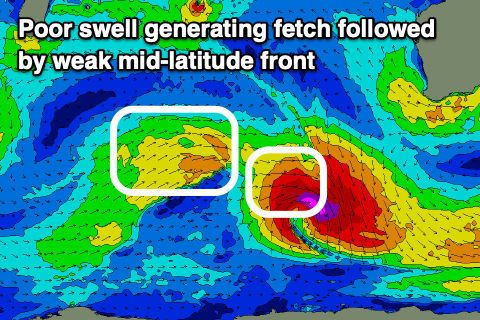 It's eastern flank will be great, but the severe-gale NW fetch will be aimed to the pole, while the backside of the low looks very average for swell generation.
Therefore we can expect poor surf on the weekend with no real size.
A small mid-period W/SW swell should be seen on Monday, generated by a weak mid-latitude front trailing the low, but size wise, the South West should see 3-4ft sets, with 1-1.5ft waves across locations to the north, likely under the size of the local windswell.
The improvement in winds early next week will be as a strong high moves in and under us, but swell wise there's nothing on the cards at all.
Longer term there's still no change to the outlook, so if expecting to surf, lower those expectations right down.
Comments
That feels like a kick in the guts : o