Great waves over the coming days

Western Australia Surf Forecast by Craig Brokensha (issued Wednesday 5th August)
Best Days: Protected spots today, tomorrow, Friday, Saturday protected spots
Recap
Easing swell with average conditions across the South West yesterday and an easing swell, small this morning with less than ideal winds again. Perth and Mandurah were OK yesterday morning though average today with the smaller swell.
A large new long-period W/SW groundswell that's due to build across the state today is now showing across the South West with sets to 6ft+ with an improvement in the wind (strong S/SE). We should see the size hitting 8-10ft this afternoon with 3ft sets in Mandurah and 2-3ft waves across Perth.

Swell on the build
This week and weekend (Aug 6 - 9)
While today's inconsistent W/SW groundswell has taken a little while to kick in, the reinforcing pulse of SW groundswell for tomorrow morning should come in with a bit more consistency.
Early sets from 8-10ft are still expected across the South West, 3ft in Mandurah and 2-3ft across Perth, easing through the day and further Friday.
 Conditions look great as a high finally edges in from the west tomorrow, swinging winds to the E/SE across all locations tomorrow morning, fresh through the morning and SE into the afternoon.
Friday will be great as the swell eases with a fresh and gusty E/NE breeze, easing and tending more variable into the afternoon.
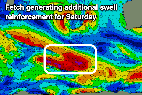
Our new inconsistent SW groundswell for Saturday is on track, generated by a more distant polar frontal progression west of the Heard Island region. This has since weakened, but an additional fetch of gale to severe-gale W/NW winds aimed poorly through our swell window will help reinforce this distant energy.
The South West should see building sets to at least 6ft through Saturday, if not for the odd 8ft cleanup, 2ft+ in Mandurah and 1-2ft across Perth, easing Sunday.
Winds will strengthen further though as a strengthening mid-latitude low moves in from the west, with strong to near gale-force (in the afternoon) E/NE tending NE winds.
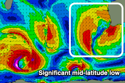 Sunday will become poor with the stronger gale-force N/NE-NE winds across the South West, a touch weaker to the north, shifting N/NW into the afternoon as the mid-latitude low pushes east bringing plenty of rain with it.
We'll also see a poor quality NW windswell for Monday morning and then larger, stormy W/SW swell generated not by local winds (which will be strong W/SW) but by a fetch of strong to gale-force SW-W/SW winds wrapping around the north-western flank of the low.
The models diverge regarding when this low will clear to the east and allow winds to improve, so we'll have to have a closer look at this on Friday.
Comments
Cooking!
Nice!