Building swells with windows between the onshores

Western Australia Surf Forecast by Craig Brokensha (issued Monday 20th July)
Best Days: Selected spots tomorrow and Perth and Mandurah for the keen early Wednesday, Friday, Sunday
Recap
Poor and solid 10ft+ waves on Saturday across the South West, easing Sunday and lumpy early but cleaning up through the day along with a new pulse of S/SW groundswell.
Mandurah was a great 3ft on Saturday morning, 2-3ft in Perth, a bit smaller but still really fun Sunday.
Today the surf is pumping with the reinforcing S/SW groundswell from yesterday still coming in at 5-6ft with excellent conditions, 2ft in Mandurah and also 2ft on the sets across Perth.
This week and weekend (Jul 21 - 26)
We've got a return to large and mostly onshore conditions for the coming period thanks to a strong node of the Long Wave Trough moving in from the Indian Ocean, but there'll be windows in between fronts.
 Tomorrow will be smaller size wise early ahead of a new inconsistent W/SW groundswell building into the afternoon. This and a secondary larger swell for Wednesday were generated by a not overly favourably structured frontal progression south-east of South Africa and Madagascar late last week.
Building surf to 5-6ft is due across the South West tomorrow afternoon, 2ft in Mandurah and 1-2ft across Perth, with a secondary pulse Wednesday coming in a bit bigger and to 6-8ft, 2ft to occasionally 3ft and 2ft+ respectively.
An approaching but weak mid-latitude low will bring average though workable gusty NE breeze early tomorrow, shifting N/NE and strengthening through the day. Wednesday will then be poor across the South West with gusty N/NW winds, strengthening through the day and NE winds early around Perth and Mandurah.
Thursday will be poor everywhere as the first of a series of mid-latitude fronts pushes through, bringing strong W/SW tending weaker S/SW winds.
It'll be short-lived but intense with a burst of strong to gale-force W/SW winds kicking up a stormy windswell Thursday to 8ft+ through the day across the South West, 3ft in Mandurah and 2-3ft in Perth.
There's a window of clean conditions Friday in between fronts with an offshore E/NE breeze due, swinging N'ly into the afternoon.
Size wise we should see some fun easing 6-8ft sets across the South West, 2-3ft in Mandurah and 2ft+ across Perth.
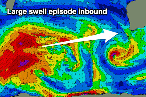
Later in the day Friday but more so Saturday a large new long-period W/SW groundswell is due, followed by a larger increase through Sunday/Monday.
Saturday's swell is currently being generated a great polar storm west of the Heard Island region. A fetch of gale to severe-gale W/SW winds are being aimed through our south-western swell window, while a secondary patchy fetch of similar strength of W/SW winds are due to develop on its tail.
This fetch will consolidate mid-week though and project north-east and more into our western swell window, breaking down while well west of us on Thursday.
This will result in two large pulses of long-period swell, the first least consistent and smaller, with the second larger and more consistent. Unfortunately the remnants of the progression will edge in on the weekend, bringing strengthen N tending NW winds on Saturday, though Sunday may see another window of variable and offshore winds.
Size wise Saturday's swell looks to be around 6-8ft+, with Sunday's building to 10ft to occasionally 12ft across the South West through the afternoon. Mandurah should be an inconsistent 2-3ft Saturday, 2ft in Perth, with bigger 3-4ft and 3ft surf respectively developing Sunday.
Into early next week winds will swing back onshore as the progression of storms edges closer but there should be windows to the north and we'll also see an even larger swell for mid-week. But more on this Wednesday.