Good run of waves this period

Western Australia Surf Forecast by Craig Brokensha (issued Monday 1st June)
Best Days: Tomorrow, Wednesday selected spots, Thursday, Friday, Saturday selected spots, Sunday South West magnets
Recap
Large and sloppy waves across the South West on Saturday, cleaner and solid though still lumpy and to 3-5ft across Mandurah, 3ft in Perth
Sunday remained large across the South West with a reinforcing swell but with persistent onshore winds which moved into Perth and Mandurah as well.
Today we've finally seen conditions clean up across the South West with easing 6-8ft sets, clean and to 3ft in Mandurah and 2-3ft in Perth. This afternoon conditions are still great across most locations..

This week and weekend (Jun 2 – 7)
Tomorrow will be fun again across all locations as the swell continues to drop in size from the weekend. Winds will be great and offshore from the E/NE, tending variable into the afternoon with easing sets from 4-5ft in the South West, 2ft in Mandurah and 1-2ft in Perth.
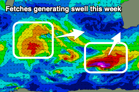 Our new background W/SW groundswell for Wednesday hasn't changed, generated by a distant but persistent Southern Ocean storm south-east of South Africa on the weekend. Also in the mix will be a more consistent S/SW groundswell, generated by a strengthening front late in our southern swell window today. While not ideally aimed, a fetch of severe-gale W/NW winds should kick up 5-6ft waves across the South West by mid-morning, while Mandurah and Perth will be tiny ahead of the new inconsistent W/SW groundswell to 2ft and 1-2ft respectively late in the day.
Both swells should ease from a similar size Thursday morning (likely 4-6ft in the South West). Conditions should be OK Wednesday as winds shift more NE and then N into the afternoon but ease in strength. Thursday should see better and light E/NE winds through the morning ahead of a S'ly change as a trough moves through.
Our new W/SW groundswell for Friday is still on track and it looks to be similar in size to the one before it, though a touch more consistent.
This is being generated by an OK but weakening fetch of W/SW gales that are currently moving in from the west, south-east of Madagascar. The track west through our swell window is good and we'll likely see a touch more consistent size to 5-6ft building across the South West into the afternoon, 2ft+ in Mandurah and 2ft across Perth.
Winds look great and fresh offshore out of the E Friday morning, variable into the afternoon with stronger NE tending N/NE winds on Saturday as the swell eases and a weakening trough slides past to our south-west.
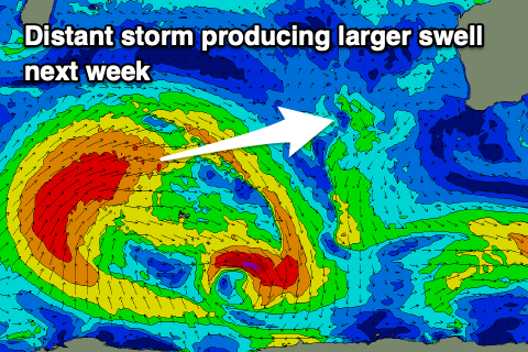 We'll see the size continue to fade into early next week ahead of a new inconsistent W/SW groundswell mid-next week. This will be generated by a broad and slow moving frontal progression again forming south-east of South Africa and projecting east and then north-east up towards Indonesia.
The only issue with this swell are the local winds as a deepening low west of us squeezes a strong high, bringing N'ly winds as the swell fills in. We'll have a closer look at this and the swell generated by this low on Wednesday and Friday.