Large windy weekend, cleaner next week as it settles

Western Australia Surf Forecast by Craig Brokensha (issued Friday 29th May)
Best Days: Perth and Mandurah tomorrow morning, all locations Monday and Tuesday, Wednesday in the South West, all locations Thursday and Friday
Recap
No let up in the onshore winds and poor conditions across the South West yesterday, but Mandurah saw winds tend lighter N'ly for a period through the morning, similar in Perth before tending back stronger onshore.
This morning all locations are poor with strong onshore winds and waves to 8-10ft in the South West, 3-4ft in Mandurah and 3ft across Perth.
This weekend and next week (May 30 – Jun 5)
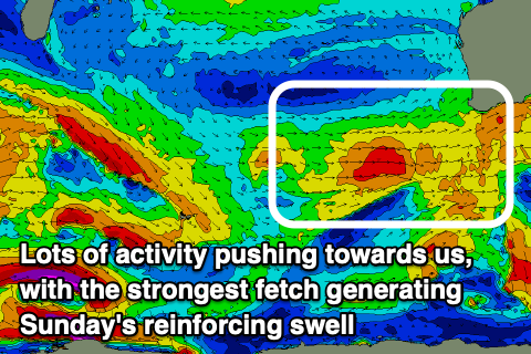
A large groundswell is currently building across the state and we should see it reaching 10-12ft across the South West this afternoon, 3-5ft in Mandurah and 3-4ft across Perth. This swell was generated by an elongated fetch of W/SW gales projecting up and into us, moving off east this morning.
The swell should come in around a similar size tomorrow morning, reinforced by a secondary front that's currently pushing up and into us.
 Unfortunately winds will remain poor and onshore across the South West with a fresh to strong SW tending W/SW-W breeze. Perth and Mandurah should see variable winds in the morning, before shifting onshore around midday or so.
Sunday then looks onshore across all locations with strong but easing W/SW tending SW winds as the swell eases a touch. It'll still be large though owing to Saturday's front projecting a fetch of strong to gale-force W/SW winds towards us.
8-10ft waves are due most of Sunday, 3ft+ in Mandurah and 3ft in Perth, then easing from 8ft or so on the sets Monday morning in the South West, 3ft in Mandurah and 2-3ft across Perth.
Winds will finally improve Monday and swing E/NE across the South West, straight E'ly in Mandurah and Perth, variable into the afternoon.
Tuesday looks great as well though the swell will be smaller, weaker and easing with fresh E/NE tending variable winds.
For the rest of the week, inconsistent background swells though with a bit of size for the South West are due, generated by a strong but distant frontal activity south-east of South Africa.
The models are incorrectly combining mid-range existing energy with the long-period signal and over-representing the size, but we should see some new swell slowly building Wednesday and peaking later or more so Thursday to 4-6ft or so in the South West, 2ft in Mandurah and 1-2ft across Perth.
A slightly better swell may be seen Friday to 5-6ft+, 2ft+ and 2ft respectively but we'll have a closer look at this Monday. Winds look favourable and from the E/NE each morning, more N'ly into the afternoons. Have a great weekend!