Fun and easing tomorrow, new swell for early next week

Western Australia Surf Forecast by Craig Brokensha (issued Friday 10th January)
Best Days: Saturday morning South West swell magnets, Monday morning, protected spots Tuesday morning and Wednesday morning
Recap
A slow start to the day yesterday but a rapid jump in swell across all coasts through the day, large in the South West, solid in Mandurah and less so Perth but along with onshore winds.
This morning the surf has cleaned right up and there was still plenty of size about, easing from 6ft in the South West, 2-3ft in Mandurah and 2ft across Perth.
This week and weekend (Jan 11 - 17)
The swell will continue to ease into tomorrow but conditions will be great across the South West with a fresh E/NE offshore, tending lighter N'ly through the day ahead of sea breezes. Easing sets from 3-4ft are expected, 1ft to maybe 2ft in Mandurah and tiny in Perth.
Come Sunday there should be an inconsistent new SW groundswell, mixed with building mid-period swell but more so into Monday/Tuesday.
Winds early Sunday look favourable and out of the S/SE in the South West (but with only 3-4ft+ or so of swell), shifting S/SW quickly and strengthening as the frontal system linked to Monday/Tuesday's swell clips the state.
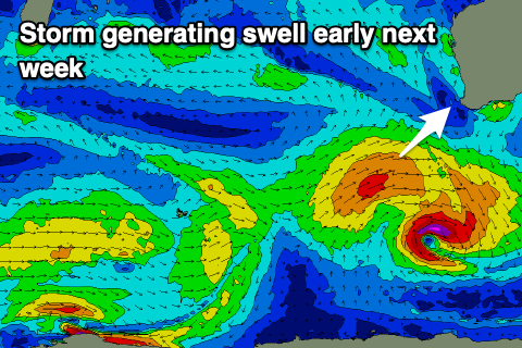 This swell started to be generated mid-week and the front linked to it is forecast to generate a fetch of strong to near gale-force W/SW winds through our south-western swell window this evening, tomorrow and Sunday.
The size of the swell isn't anything too substantial but we should see the South West building Monday to 5-6ft later in the day, easing from 4-6ft Tuesday, with 2ft sets in Mandurah and 1-1.5ft across Perth.
A fresh and gusty but better SE breeze is expected on Monday morning, windy and more onshore into the afternoon, with Tuesday possibly seeing less favourable S/SE-SE winds in the morning. We'll have to review this Monday.
Similar and stronger S/SE-SE winds are expected on Wednesday as the swell continues to ease, favouring protected locations only.
Longer term small to moderate levels of background SW swell are due into the end of next week and weekend with morning SE winds. We'll also keep an eye on the formation and track of another tropical cyclone off our north on Sunday evening, but more on this Monday. Have a great weekend!