Slow start to December

Western Australia Surf Forecast by Craig Brokensha (issued Monday 2nd December)
Best Days: Tomorrow morning in the South West, Sunday morning protected spots in the South West, Monday morning swell magnets in the South West
Recap
Tiny to flat conditions across Mandurah and Perth all weekend, with small waves across the swell magnets in the South West for keen surfers.
A new inconsistent W/SW groundswell due today was a bit slow to get going, though with a slight increase to 3-4ft down in the South West, tiny to the north. The sea breeze came in early as sets pushed to 4-6ft across the swell magnets, though Perth and Mandurah are struggling to offer anything surfable.
This week and weekend (Dec 3 - 8)
Today's building inconsistent W/SW groundswell is due to ease through tomorrow and with the lack of size across Mandurah and Perth tomorrow, there's not much due in the morning. Hit the South West for a wave with easing sets from the 4ft+ range, with a fresh morning E/NE breeze, tending variable ahead of afternoon sea breezes.
Less favourable S/SE winds are due Wednesday morning as the swell continues to ease.
Come Thursday a small background swell should keep inconsistent 3ft sets hitting the South West swell magnets with a morning SE breeze, bottoming out Friday with a morning E/NE breeze.
As talked about on Friday, a new W/SW swell is due on the weekend, though the remnants of the progression linked to it will move through on Saturday bringing onshore W/SW winds.
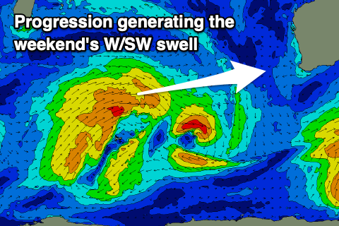 The frontal progression has developed just north-west of Heard Island and we'll see a fetch of strong W/SW winds projected through our western swell window this evening and tomorrow, before it weakens Wednesday.
Size wise, we should see surf to 4-5ft+ across the South West Saturday, 1-2ft in Mandurah and Perth, easing Sunday from 4ft and 1-1.5ft respectively with slightly better but still average morning S/SE winds.
Monday morning looks cleaner, but with small leftovers across the South West.
Longer term, a strong but distant storm developing south-east of South Africa is due to generate an inconsistent long-period W/SW groundswell for the middle of next week with what looks to be S/SE winds, but more on this Wednesday.
Comments
Maybe got to 4 foot but definitely not 6 foot , unless we are talking face height
Yea, I'd say it was barely overhead on the sets. Defs no 6ft
Ah was watching some 1.5-2x overhead ones at Boaties on the cam, but it's the magnet to kill all magnets.
Whaddyareckon......is the Kimberley looking at a cyclone before Xmas or not ?