Not the best weekend, clean fun waves early next week

Western Australia Surf Forecast by Craig Brokensha (issued Friday 4th October)
Best Days: Protected spots desperate surfers tomorrow AM, keen surfers in the South West Sunday and Monday AM, Tuesday, Wednesday AM in the South West
Recap
Large building surf with favourable winds most of yesterday across the South West and fresh offshore winds, good in Perth and Mandurah through the morning ahead of sea breezes.
Today strong offshore winds were grooming the large easing swell with clean 8ft+ sets at dawn, while to the north, Perth and Mandurah were wind affected as the northern flank of a low sitting off the coast started to edge in.
This weekend and next week (Oct 4 - 11)
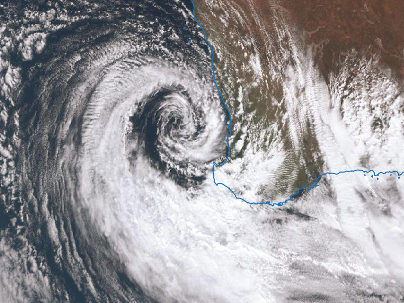 We'll see the strong but weakening low (pictured right) moving across us this evening and early tomorrow, with it stalling just a little compared to forecasts on Wednesday. This will see S'ly-S/SW winds across most locations tomorrow, possibly S/SE at dawn around Perth and Mandurah but mostly wind affected.
The surf will continue to drop in size with 4-6ft sets across the South West, 2ft in Mandurah and Perth on the sets.
Sunday morning is still looking cleaner, but tiny in Perth and Mandurah, with a small background swell across the South West to 3-4ft+. A light morning SE to E/SE breeze is expected across the northern half of the cape ahead of sea breezes.
Monday morning will be nice and clean with an E/SE offshore but the swell on the small side and to 3-4ft in the South West ahead of a new mid-period SW swell into the afternoon.
This has been generated by a relatively weak but persistent fetch of strong to near-gale-force fetch of W/SW winds through our swell window the last few days.
Margs should build later Monday and peak Tuesday morning to 6ft on the sets , 2ft+ across Mandurah and 1-2ft in Perth. Late sea breezes are likely into Monday, with Tuesday seeing E/NE tending variable winds ahead of sea breezes.
Wednesday morning will be clean again but smaller with the swell on the ease.
Longer term there's nothing too significant on the cards until later next week and next weekend.
This will firstly be in the way of a new long-period SW groundswell Friday from a strong polar low in our far swell window, mixed in with local windswell as a mid-latitude front pushes into us.
Some larger swell is on the cards for the weekend and following week, but the models still diverge a little on the strength of the systems. More on this Monday. Have a great weekend!