Good swell for the coming days but with average winds

Western Australia Surf Forecast by Craig Brokensha (issued Monday 26th December)
Sign up to Swellnet’s newsletter and receive the West Australian Forecaster Notes and latest news sent directly to your inbox. Upon signup you'll also enter the draw to win a surf trip to P-Pass for you and a mate. It doesn’t get much easier so click HERE to sign up now.
Best Days: Thursday morning, Saturday morning, Sunday morning
Recap
A large powerful SW groundswell filled in on Saturday but S/SW winds limited surfing options across the South West to protected spots. The swell was big enough to get into these locations, with easing and better 8-10ft waves Christmas morning under improving offshores ahead of sea breezes.
Perth saw 2ft waves Sunday morning with a less than ideal S/SE breeze and cleaner 2-3ft waves in Mandurah.
The swell eased through the day, but was still solid this morning due to the long-lived nature of the low that generated it.
Conditions were clean across all locations with 5-6ft sets in the South West, 2-3ft waves around Mandurah and 2ft in Perth. A W'ly change is due through the day linked to a mid-latitude low approaching from the south-west.
This week and weekend (Dec 27 - Jan 1)
The low currently moving in from the south-west has generated and will continue to generate a large SW groundswell for us tomorrow and Wednesday morning, but winds will be average as the low stalls south of Esperance tomorrow evening and re-intensifies in the Bight.
We should see Margs building to 6-8ft+ tomorrow afternoon, with an increase to 2-3ft during the day in Perth but with strong SW tending S/SW winds.
S-S/SW winds are likely to linger across both coasts into Wednesday keeping conditions well below average as the swell eases from 6ft+ and 2-3ft respectively.
 Thursday looks cleaner with a morning E/SE'ly around Perth and SE winds in the South West but the swell will be small and easing from 3-5ft and 1-1.5ft respectively.
It should be noted the southern coast of the state will see a strong S/SE groundswell Wednesday afternoon and Thursday morning from the bottom side of the low stalling in the Bight.
This won't get into Margs at all let alone Perth.
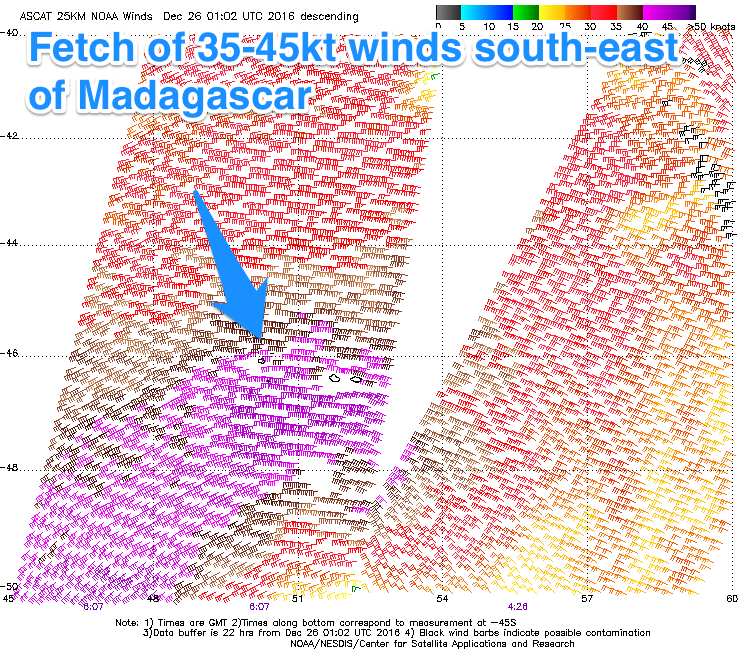
Into the end of the week an inconsistent but moderate to large W/SW groundswell filling in, generated by a strong and slow moving polar low that's currently south-east of Madagascar.
A fetch of gale to severe-gale W/SW winds are being projected through our swell window, with the low continuing east over the coming days before breaking down east of Heard Island during Wednesday.
The swell will be inconsistent but good, with the long-period fore-runners arriving Thursday evening ahead of the groundswell proper building Friday.
Margs should build slowly towards 5-6ft+ Friday afternoon in the South West and 1-2ft in Perth, holding a similar size Saturday across both regions.
A S/SE tending S/SW breeze on Friday won't be ideal but Saturday looks great as a ridge of high pressure moves in from the west, swinging winds E/SE during the morning.
Sunday looks similar with some smaller reinforcing SW swell on the cards, but more on this Wednesday.