Average tomorrow, fun Sunday and early next week

Western Australia Surf Forecast by Craig Brokensha (issued Friday 11th Novemeber)
Best Days: Sunday before sea breezes kick in across the South West, Monday, Tuesday morning
Recap
A window of clean conditions across all coasts yesterday with 4-5ft sets in the South West and fun 1-2ft waves further north. It didn't take too long for onshore winds to kick in though, creating poor conditions for the rest of the day and into this morning.
This weekend and next week (Nov 12 – 18)
Onshore winds will continue across the South West tomorrow with 3-5ft of background SW swell, and tiny waves around Perth. An offshore SE'ly should be seen further north though, creating clean conditions.
There's been no real change to Sunday's swell with, clean conditions expected across all locations through the morning but similar sized waves to Saturday ahead of the new SW groundswell into the afternoon.
We're probably looking at 4-6ft waves developing across the South West reefs and 1-2ft sets in Perth, easing back from 4-5ft and 1-2ft respectively Monday morning.
Conditions should be clean again through the morning though with a moderate E'ly tending E/NE breeze ahead of more variable winds into the afternoon.
Early Tuesday will be smaller again but workable at spots protected around Margs from a gusty N/NE wind that will swing more N/NW through the morning.
 The large mid-period swells due through the week has been downgraded a bit, but there was no quality due with this swell in any case.
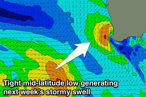
Some distant W/SW groundswell is due Wednesday but with freshening NW winds, while into Thursday a weak polar front pushing up towards us will then form into a tight mid-latitude low right off our South West.
This will see strong S/SW winds projected towards us, with possibly gale-force S/SW winds right off Mandurah and Perth.
Poor onshore and weak amounts of S/SW swell are expected for Thursday with 5-6ft waves in the South West and 2-3ft storm surf around Perth.
Friday doesn't look much better as the swell eases with straight onshore W'ly winds.
Longer term some stronger long-period W/SW groundswell is due into the weekend and early next week but with what looks to be onshore winds as cold fronts continue to ride high through the Indian Ocean.
This is a result of a negative Southern Annular Mode (SAM) which results in the westerly storm track being positioned closer towards the equator rather than the poles.
Long term forecasts don't have the negative SAM index returning to neutral until later in the month, so we may have to put up with these average conditions for a while.
Check back Monday for the latest. Have a great weekend!