XXL swell for Sunday with gale-force but easing onshore winds

Western Australia Surf Forecast by Craig Brokensha (issued Monday 25th July)
Best Days: Novelty spots later Sunday, Monday in Perth and Mandurah, Tuesday all coasts early
Recap
Good clean conditions all day across the South West with sets either side of 5ft, while further north the swell was back to a tiny 1ft or so.
This morning a strong new SW groundswell has filled in with 6-8ft sets across the South West and 2ft sets to the north. Conditions were favourable across all coasts early, but winds are now more N'ly and starting to increase with an approaching front.
This weekend and next week (Jul 29 – Aug 5)
We're currently starting to feel the effects of a strong mid-latitude front approaching the state, and behind these pre-frontal N/NW winds, a stronger fetch of W/SW gales are producing a large W/SW groundswell.
This swell will fill in tomorrow and build to a large 10ft across the South West through the day with 3ft+ sets developing around Perth into the afternoon.
Conditions will be a complete mess in the South West though with a fresh to strong W/NW breeze, reaching the gale-force range into the afternoon. Perth will see weaker moderate to likely fresh W'ly winds, increasing through the day.
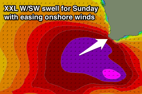 Now, directly behind today's approaching front will be a much stronger mid-latitude frontal system, projecting a fetch of severe-gale to storm-force W'ly winds on top of the active sea state generated by the first front, generating an XXL W/SW groundswell for Sunday, peaking through the middle of the day/afternoon.
The South West will be a stormy 15-20ft or so (larger at offshore bommies) with Perth coming in around 4-5ft into the afternoon. Conditions will be terrible with a gale-force but easing W/SW tending SW breeze.
Come Monday a ridge of high pressure is expected to move in quickly in the wake of Sunday's onshore winds, and this should see winds swinging offshore across Perth and Mandurah from the E/SE, but Margs is tricky.
The models are diverging slightly on how quickly the high will move in the South West, with the European version being more favourable resulting in variable tending N/NE winds. GFS the American version is a bit slower and this will result in moderate SW winds, easing through the day and possibly becoming more variable.
Either case conditions will still be raw and dangerous in the South West through the morning, improving through the day.
The XXL W/SW groundswell will ease steadily, dropping from the 15-18ft range across Margs (larger at offshore bommies) with easing 3-5ft sets around Perth.
Smaller surf is then due Tuesday with E/NE tending N/NE winds.
Longer term there's nothing significant for the rest of the week until Friday when a moderate to large sized W/SW swell fills in and winds are looking generally unfavourable. More on this Monday, have a great weekend!
Comments
Jeez, it's not small this morning.
Dont undercall it boys ive tried to explain before 8 metre @18 sec is not 15-20 ft
Very good , thanks ben , supersized yalls ?
Was watching the stream on my iPhone whilst having dinner with the family and saw this bomb come through, so took a screen shot (hence the low quality). Hard to put a size on it but it's pretty big!
And all the buoys are down :(
And they're back!
Grabbed a few frames when I got the site up thru the day , at 9 am got buoy at 7.3@18 & I think it got bigger afterwards ! .
Back now, yeah looks like got touch bigger...
Bit of windswell in the mix there as well, about 3m.
How big is it over your way? Should be filling in now.
Massive still all day , still 4.6@16 mon arvo . Its coming in hot just saw almost 15ft freak set out the point . .far from filled in tho craig im watching the arrivers now at your fav left
Very big today at exposed spots. Checked my local yalls area big wave spots and they were maxing with the west-ish swell. Dropped very slowly over the day as well