Windy conditions Saturday; fun surf Sunday, then a very large groundswell late Tues/Wed

West Australian Surf Forecast by Ben Matson (issued Friday 27th May)
Best Days:
Sunday: fun waves across metro beaches. Monday: moderate, easing clean swells across the Margs coast. Tues PM/Wed: very large SW swell with light offshore winds in Margs. Solid surf at metro beaches too. Thurs/Fri: good winds across all coasts with easing swells.
Recap:
Large windy surf on Thursday, easing from 8ft+ to 6ft+ across the Margs coast, before levelling out at 4-5ft this morning with early moderate N/NE winds tending fresh S’ly during the day. Surf size was solid across Mandurah and Perth coasts on Wednesday but bumpy under an onshore breeze. This morning offered smaller, cleaner waves with light offshore winds. Size is in the 2-3ft range across Perth beaches with slightly bigger waves in Mandurah, and the favourable winds have lasted all day.
This weekend (Saturday 28th - Sunday 29th):
Saturday is a write-off in general.
An approaching cold front will strengthen NW winds overnight before a SW change arrives early-mid morning, initially at gale force strength about the lower SW with slightly less strength across Mandurah and Perth coasts. But still quite strong at times.
These winds won’t allow for any favourable conditions, and although we’ll see a combination of swells from several sources - in fact, our model has two swells from the W/SW across the Margs coast at 20 seconds and 16 seconds, plus a third, 13 second swell from the SW - quality will be hard to find. Exposed coasts should building to 6-8ft+ throughout the day but you’ll really have to wait until mid-afternoon once winds have swung more S/SW when we’ll see reasonable waves on offer across the protected bays and points. Prior to then the wind’s likely to have too much west; it’ll take a while for these locations to clean up following the directional change in the wind.
Metro beaches in Perth and Mandurah will have plenty of solid waves both days but it’s not worth getting too excited about.
Sunday on the other hand looks really good for metro beaches around Perth and Mandurah. Saturday’s front is expected to clear quick to the east, leaving the coast in a light SE airstream, and the building groundswell is expected to reach a peak with 3ft+ waves in Perth and up to 3-4ft+ in Mandurah. There’ll still likely be some wobble on top but it’ll be a vast improvement from Saturday.
Surface conditions will take a lot longer to improve across the Margs coast on Sunday but with 8-10ft+ of swell on offer here shouldn’t be any shortage of size across exposed reefs, and therefore protected locations should also have good solid waves too. It'll be well worth the effort as winds will rapidly ease from the S/SW, tending moderate S’ly early morning and eventually S/SE throughout the day.
Next week (Monday 30th onwards)
We’ve got some excellent large waves on the way for the Margaret River region next week.
A blocking pattern upstream (i.e. across the Tasman Sea) resulting from a slow moving high pressure system will back up a series of Southern Ocean fronts and lows across the southern Indian Ocean, resulting in a conveyer belt progression this weekend and into early next week.
Monday will start off with light variable winds and solid but easing swells from Sunday, somewhere in the 6ft+ range at exposed spots around Margaret River to begin with, and a little smaller throughout the afternoon.
An intense front and low tracking north of Heard Island on Saturday morning is expected to display 50-60kts of W/SW wind, aimed right into our prime swell window. The large travel distance is of some concern but the forward motion of the storm is very favourable, and it’ll be working on top of a very active sea state (around a strong parent low further south).
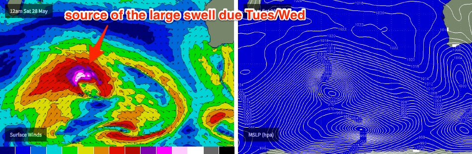
The leading edge from this swell is expected to reach the coast in the early hours of Tuesday morning, and we should see a rapid increase in size all day (mainly the afternoon), bolstered by a second, mid-range swell originating from the parent low that'll arrive after lunch. Wave heights are expected to reach 10-12ft across most exposed reefs by late in the day, and local winds are expected remain light from the NE so it’ll be very clean on top. Offshore bombies should punch well north of 15ft+ as this swell reaches a peak.
We’re looking at a slow easing trend from Wednesday morning onwards, and again, light NE winds thanks to a broad ridge of high pressure over the state. Early morning sets should manage 10ft+ at exposed spots though it’ll probably drop to 6-8ft during the day. A further easing is then expected through Thursday and Friday.
This same swell should produce excellent waves across Perth and Mandurah beaches too, reaching a peak around 3-4ft in Perth very late on Tuesday or early Wednesday, and a little bigger at Mandurah. Surface conditions also look excellent with light NE winds.
Looking beyond this, and an active frontal progression trailing behind doesn’t look very well aligned for the coast so it’s likely that moderate swells will eventuate next weekend and possibly an onshore airstream as the dominant high pressure ridge breaks down. However a series of deep polar lows are modelled to develop east of Heard Island later next week which suggests another round of very large surf early in the following week. More on this in Monday’s update.