Small swells continue with generally favourable winds

Western Australia Surf Forecast by Craig Brokensha (issued Monday 26th October)
Best Days: Swell magnets in the South West Tuessday/Wednesday/Thursday mornings and then Sunday and Monday
Recap
Average 3-4ft waves across the South West Saturday with a S/SE breeze, while Perth was also average with tiny 1-1.5ft waves and a S'ly breeze.
A slight kick in SW groundswell Sunday saw better 3-5ft waves across Margs with better winds, swinging E/SE through the morning creating fun conditions. Perth was also cleaner but only to 1ft.
Today the surf was easing from 3-4ft in the South West with improving winds through the day, while Perth was hanging around the 1ft range.
This week (Oct 26 - 29)
Nothing too major to talk about over the coming week, with the surf due to ease back further through tomorrow with favourable offshore E'ly winds and afternoon sea breezes. Swell magnets in the South West will be the pick with 3-4ft sets, smaller into Wednesday but offshore again through the morning. Perth will become really tiny to 0.5ft or so.
Thursday will continue to see small levels of background swell energy, offshore from the E/NE Thursday morning while Friday will be poor with NW tending W'ly winds. This will be as a new SW groundswell fills in, generated by a broad fetch of W/NW gales around the Heard Island region today, pushing east over the coming days.
This should come in at 4-5ft across the South West but hardly impact Perth. Conditions will be poor as explained above anyway.
This weekend onwards (Oct 31 onwards)
Friday's kick in SW swell is due to ease back through Saturday and winds look less than ideal with a lingering S/SW'ly across the South West, and better S/SE winds around Perth but no size.
Sunday should see cleaner conditions as winds swing offshore from the E/NE with a mix of S/SW swell and late arriving long-range SW groundswell.
The S/SW swell will be produced by a deepening but unfavourably positioned and late forming low to our south-southwest during Friday. A fetch of S/SW gales will be aimed towards us while tracking south-east, producing a limited S/SW swell to 4-5ft or so across swell magnets.
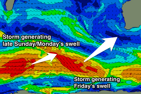
Into the late afternoon a very inconsistent long-range SW groundswell is due, generated by a good storm firing up west of Heard Island over the coming days, but weakening once pushing east of it.
Only a very late pulse to 4-5ft is likely, peaking Monday morning to 5-6ft or so across Margs. Perth should see 1-1.5ft sets Monday, with the possibility of the odd 2ft bomb.
Conditions look great again with E'ly offshores ahead of sea breezes.
Longer term there's still nothing significant on the cards besides long-range groundswell energy, but without any major size. More on this Wednesday.