Easing swell with light/variable winds mid week

West Australian Surf Forecast by Guy Dixon (issued Monday 10th August)
Best Days: Tuesday afternoon, Wednesday, Thursday.
Recap: Sunday saw a solid kick in swell with the South West picking up surf in the 8ft+ range. Unfortunately this swell event coincided with a front which resulted under persistent strong westerly component winds which shut down any chance of a decent wave.
Further north, the swell kicked to the 3ft mark across the Mandurah and Perth stretches, with a morning of light/variable winds and clean conditions with only a few residual surface lumps. The afternoon saw conditions deteriorate as winds swung onshore.
This week (Monday 10th - Friday 14th):
Off the back of Sunday’s swell event generated by a broad frontal progression which moved across the Indian Ocean last week, we have plenty of residual ground swell filling in. Similarly to yesterday however, a strong onshore flow steered by front is creating especially poor conditions right across the WA coastline. The South West is seeing surf in the 8ft+ range, Mandurah 3-4ft and Perth with 2-3ft peaks, but each location is severely wind affected, choppy and blown out. There are little to no options for a decent wave, but plenty of size if you don’t mind battling the turbulent conditions at metro beaches.
A fresh pulse generated by a fetch of west/southwesterly gales will impact the South West on Tuesday maintaining surf in the 8ft+ range and 2-3ft surf along the Perth stretch.
By that stage, a ridge will have begun to establish itself over WA allowing winds to ease. Initially the South West will be under a moderate/fresh south/southwesterly flow, easing into the afternoon. Options will be limited early, but will open up as the afternoon progresses with protected spots offering decent conditions. Across the metro stretch, southerly breezes will be gusty early, easing significantly in the afternoon. The will offer the best conditions with the most size and lightest winds. It’s worth considering that there will be a degree of scarring and wobble in the surf so soon after winds abate.
The following days will see an easing trend despite a weak, barely discernible pulse late on Wednesday afternoon evening. Much of Wednesday will have surf in the 4-6ft range across the South West, easing throughout the day. Thursday will see the swell fade further to around the 3-4ft range. Perth and Mandurah will fade back to the 1-2ft mark on Wednesday, becoming tiny on Thursday.
Fortunately winds look to be light and variable with the high situated directly over head across the Metro beaches on Wednesday allowing for clean conditions all day on Wednesday, tending light onshore on Thursday.
Being further south, the South West is looking to be under a light west/southwesterly flow on Wednesday morning, tending due west in the afternoon. On Thursday, a weak front will slip to the south of the mainland, but will cause winds to tend west/northwesterly and strengthen ever so slightly. Yes, it'll be onshore, but it should be light enough to be able to find protection fairly easily. The set up also looks conducive to early morning offshore breezes that the models struggle to pick up on so keep an eye out.
A small but intense polar low and associated front is looking to develop east of Heard Island late on Tuesday, moving east throughout Wednesday. The low itself looks to have a bout 12 hours of severe gales, although the fetch is pretty tiny. The associated front will generate the bulk of the swell and should bring a slow increase in size for Friday (two separate period pulses generated by the same complex front). At this stage, it looks as though the South West will build into the 4-6ft range and 1-2ft for Perth/Mandurah.
Perth and Mandurah are likely to be under a light northeasterly breeze in the morning, tending more northerly throughout the day and eventually onshore by afternoon. The South West is more likely to see stronger winds, light north/northeasterly early, strengthening into the afternoon.
This weekend (Saturday 15th - Sunday 16th):
At this stage, it looks as though Friday’s swell will fade to around 4ft across the South West and 1ft for Perth on Saturday under northeasterly winds tending northerly. Sunday should see the surf ease further to around 3ft across the South West and tiny elsewhere. Sunday is likely to be a lay day with poor north/northwesterly winds swinging northwestelry throughout the day.
Next week (Monday 17th onward):
 The set up for early next week is highly dependant on the development of an offshore low across the weekend. Most models agree that this system will develop, it’s just a matter of timing and position so confidence is low and the weekend forecast is very subject to change.
Monday looks to see a pulse of westerly swell generated by this offshore low (most substantial fetches on the northern quarters of the system). The metro beaches should do the best off it with peaky ground swell in the 2-3ft range, while the South West kicks to 4-6ft. Fresh/strong westerly breezes are likely to add plenty of junky wind swell into the mix.
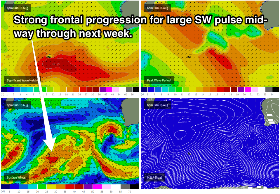
Models are showing a much more substantial southwesterly trailing fetch moving across the Indian Ocean across the weekend which holds promising prospects for bigger ground swell mid-way through the week. This system is likely to generate swell in the 8-10ft range across the South West. We will look at this system in more detail in the Wednesday’s notes. Stay tuned.