Plenty of swell with dicey winds, large and offshore Friday morning

Western Australia Surf Forecast by Craig Brokensha (issued Friday 22nd May)
Best Days: Sunday in the South West, dawn Monday, Wednesday morning Perth and Gero, Thursday afternoon protected locations around Margs, Friday morning all locations
Recap
Easing small waves across the South West, but fun and clean all day yesterday to 3-4ft, with tiny 1ft surf around Perth. Today the swell was easing from a smaller 3ft and winds are tending less favourably to the north.
This weekend (May 23 - 24)
Saturday is now looking dicey, with an early variable breeze that was due around the South West, now due to already be onshore and from the W at first light. A new inconsistent SW groundswell should build through the day and reach 3-5ft across exposed breaks through the afternoon with 1ft waves in Perth but with that onshore wind.
Sunday will be the day to surf as winds swing back offshore through the morning as the swell eases from 3-4ft and 0.5-1ft respectively. Only weak sea breezes are due around Margs as well, keeping conditions workable into the afternoon.
 Next week onwards (May 25 onwards)
Our large SW groundswell due Monday is still on track, with the vigorous polar frontal progression generating it, currently to our south-west, aiming a fetch of gale to severe-gale W/SW winds towards us.
This swell should fill in Monday and peak through the day to 6ft with the odd bigger 8ft bomb at times in the South West, with 2ft+ waves around Perth into the afternoon. Gero should build to 3-5ft.
Winds look as if they'll be variable at dawn across all locations but quickly swing onshore with an approaching front. This front will then be followed by a secondary system into Tuesday and Wednesday, keeping average 6ft waves hitting the South West Tuesday and Wednesday morning, with 2ft waves in Perth and 3-4ft surf up at Gero but with persisting onshore W/SW tending SW winds Tuesday and then better S'ly winds Wednesday (offshore around Perth and Gero early).
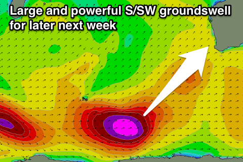
As touched on the last few updates, a larger S/SW groundswell is due into Thursday and Friday across the state, owing to a strong node of the Long Wave Trough moving in from the west during next week.
With this a vigorous polar frontal system will develop south-west of Heard Island on Monday morning, generating a fetch of severe-gale to storm-force W'ly winds, before being steered up and into us while weakening.
A large and powerful S/SW groundswell will be produced, building strongly late in the day in the South West, reaching 8-10ft+ on dark before peaking overnight and easing from the 8-10ft Friday morning.
Perth may not see a kick to 2ft before dark, but come Friday morning we should see 2-3ft waves, with Gero offering 5-6ft waves.
Winds on Thursday are looking average and onshore from the S/SW, while Friday morning looks excellent with offshore E'ly winds.
Longer term the next increase in significant swell looks to be the following week, but more on this Monday. Have a great weekend.