Oversized and clean S/SW groundswell Saturday

Western Australia Surf Forecast by Craig Brokensha (issued Friday 17th April )
Best Days: Every day over the coming period
Recap
Large clean waves again in the South West yesterday between 8-10ft as Wednesday's pulse eased back through the morning ahead of a new pulse into the afternoon. Sea breezes created average conditions into the afternoon, best suited to protected spots. Perth offered clean 2-3ft waves most of the day, and today we've got similar conditions with yesterday afternoon's SW groundswell holding a similar size across both coasts.
A weak onshore change has hit both the capes in the South West but is still variable around Margs, although this has just changed with onshores now blowing across the whole cape.
 This weekend (Apr 18 – 19)
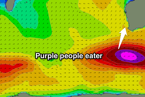
There's been no change to the large and powerful S/SW groundswell due across the state tomorrow, with satellite observations confirming a fetch of 50-55kt winds being aimed towards us, linked to a broad and vigorous polar low.
This low is still generating a fetch of storm-force SW winds through our swell window but will move out of it and to the east this evening.
An oversized and long-period S/SW groundswell will result, building through tomorrow morning and reaching a peak during the middle of the day in the South West to 10-12ft+ across Margs with large surf at deep water reefs, pulsing to 3ft+ across Perth into the afternoon.
Gero should kick late in the day to 4-5ft+ before easing from 4-6ft Sunday morning.
Winds should be great and offshore from the E tending variable into the afternoon across most locations.
The swell will drop steadily overnight Saturday, easing from 6-8ft Sunday morning in the South West and 2-3ft up around Perth. Winds are looking to be fresh from the NE, tending more N/NE into the early afternoon and variable into the evening again.
Next week onwards (Apr 20 onwards)
The weekend's large S/SW groundswell should continue to ease through Monday from 3-4ft+ across the South West and 1-2ft in Perth under fresh NE tending variable winds.
Tuesday will be the smallest day of the period, with the swell bottoming out into the afternoon, but swell magnets across the coast will be the pick under morning NE winds.
Our new pulse of SW groundswell due Wednesday has been upgraded further since last update. This is a result of a strong new node of the Long Wave Trough moving through the southern Indian Ocean this weekend and early next week, in turn feeding a surface low pressure system developing just west of Heard Island tomorrow.
This polar low is forecast to aim a fetch of severe-gale to storm-force W/SW winds towards us while tracking east over the weekend before weakening Monday only to be overridden by a couple of secondary slightly weaker but still strong polar fronts through Tuesday and Wednesday.
A large and powerful SW groundswell should be generated, arriving overnight Tuesday and peaking Wednesday to an inconsistent 8-10ft across the South West, 2ft+ in Perth and building to 3-5ft up at Gero.
A secondary pulse of slightly more southerly swell is then due Thursday afternoon followed by a smaller S/SW pulse Friday from the secondary frontal systems, but this will just soften the easing trend into the end of the week.
Winds look favourable and generally offshore from the east each morning, but we'll review this again Monday. Have a great weekend and surf within your ability.