Excellent Friday

Western Australia Surf Forecast by Craig Brokensha (issued Monday 16th March)
Best Days: Thursday in protected spots, Friday morning, Saturday early, Sunday protected spots, Monday morning
Recap
Saturday morning around Margs offered the only decent window of waves with a small clean 2-3ft of swell. Onshores and tiny wave Sunday left no options for a surf.
Today the small run of waves and onshores is continuing.
 This week (Mar 17 - 20)
Tomorrow and Wednesday will be worth leaving the board in the cover as the swell remains small to tiny under onshore winds.
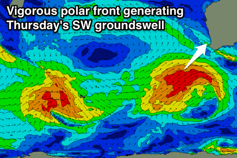
Our new pulse of S/SW groundswell due for Thursday has been upgraded and is also due to come from a better SW direction.
This swell will be produced by vigorous polar front that's already formed south-west of Heard Island.
A fetch of gale to severe-gale W/SW winds are being generated, with the front then due to be projected up towards us during tomorrow and Wednesday, swinging the fetch more SW.
A large long-period SW groundswell will result, building strongly through Thursday, peaking into the afternoon/evening in the South West, evening around Perth and dawn Friday up at Gero.
We should see exposed breaks in Margs kicking to 8-10ft+, Perth pulsing to 2-3ft late and Gero kicking to 3-4ft+ (peaking Friday morning to 5-6ft). A drop through Friday from 6-8ft is due in the South West and 2-3ft in Perth.
Conditions will improve through Thursday as the cold front responsible for the swell pushes through Wednesday evening leaving S/SE breezes across Perth and Gero, while Margs is likely to see S/SW winds, tending S/SE late in the day favouring protected locations.
Friday looks excellent with E'ly offshore winds across all locations ahead of afternoon sea breezes.
This weekend onwards (Mar 21 onwards)
Thursday's swell will continue to ease into Saturday and winds don't look as favourable with early light SW winds ahead of a cold front pushing through the day.
We're looking at another less consistent but large SW groundswell arriving through Sunday, generated by a polar low firing up in a similar position to the system generating Thursday's swell but not pushing as far north and up into us. A touch less size is then due, more in the 6-8ft range in the South West, but we'll have a closer look at this on Wednesday.
Winds look a little average and from the S/SE, but we'll review this Wednesday.
Comments
Finally!
Halloo loo ya! Been awhile between large swells. I'm frothing!