Trickier period of surf with funky winds

Victorian Surf Forecast by Craig Brokensha (issued Monday March 11th)
Best Days: Today, Wednesday when winds go light, early Thursday protected spots, selected spots Saturday and Sunday mornings
Features of the Forecast (tl;dr)
- Easing surf tomorrow with a strong S/SW change at dawn, easing and tending S
- Moderate S winds early Wed, tending light and possibly variable mid-late AM, increasing from the S/SW-SW into the PM
- Moderate + sized SW groundswell building Wed, peaking into the PM
- Easing swell Thu with tricky winds, likely W/NW-NW at dawn, then tending strong S
- Easing swell Fri with fresh S/SE winds
- Small mix of background SW swell and SE windswell Sat, smaller Sun
- E/SE tending E/NE then SE winds both Sat and Sun
Recap
It was a cracker weekend for the beaches to the east and the magnets on the Surf Coast with hot offshore winds and plenty of swell.
Friday's energy eased slowly back into Saturday with options lighting up across both west and west of Melbourne. Yesterday was smaller and best to the east with winds remaining favourable all day along with a pulse of new swell into the late afternoon/evening.
This has peaked this morning with good 3-4ft waves on the Surf Coast and 6ft sets to the east.
The swell is due to ease steadily through the day as winds remain favourable, so make the most of it.

Saturday morning goodness
This week and weekend (Mar 12 -17)
After a great run of surf the last few days, it'll be worth making the most of today's conditions and easing swell. A trough is due to move through right on dawn tomorrow, bringing an end to the good run, with strong S/SW tending weaker S winds due through the day.
Wednesday looks to remain onshore with lingering, moderate S'ly winds and a moderate + sized SW groundswell that's due to build through the day.
There's likely to be a window where winds tend more variable through the mid-late morning before freshening from the S/SW-SW into the afternoon. This will be as tomorrow's trough drifts back in from the east, bringing tricky winds into Thursday that we'll likely have to revise on Wednesday.
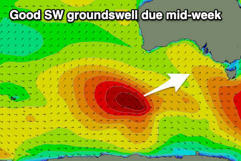
Looking at the swell and Wednesday's building energy has been generated by a strong, slow moving polar low that fired up east of the Heard Island, with a fetch of severe-gale winds due to generate a good kick in size and power. The Surf Coast should reach 4-5ft into the afternoon with 6-8ft sets to the east, easing back from 3-4ft and 5-6ft respectively on Thursday.
We'll likely see early W/NW breezes on the Surf Coast Thursday, and variable NW winds to the east, strengthening from the S'th through the day as the trough pushes back west, but check back here Wednesday for confirmation on this tricky morning window.
Unfortunately as the swell continues to ease on Friday, S/SE-SE winds will create average conditions with improving conditions and surf due again into the weekend on the beaches.
Swell wise, nothing major is due, with background levels of mid-period energy due to favour the beaches over the Surf Coast, which will see SE windswell being more dominant on Saturday.
Surf to 2ft+ is due on the Surf Coast Saturday with inconsistent 3ft sets to the east, 1-2ft and 2-3ft Sunday.
Winds look gusty out of the E/SE early Saturday, easing and tending E/NE for a period east of Melbourne during the morning, similar but slightly better Sunday.
Longer term, early next week looks to remain slow before the Southern Ocean storm track starts to fire up for the middle to end of the week. More on this Wednesday.
Comments
The Surf Coast really turned it on this afternoon I thought. The morning wobble was gone and the sets kept coming, although still a bit inconsistent. The crowds were down too.
Yep. Sick day of waves
Absolutely pumped to the east - we were down at Sandy point and it was firing!