Fun, peaky waves to end off the week

Victorian Surf Forecast by Craig Brokensha (issued Wednesday 22nd November)
Best Days: Friday beaches, Saturday beaches
Features of the Forecast (tl;dr)
- Moderate sized mid-period S/SW swell tomorrow with light-mod S/SE winds, strengthening through the day
- Slight drop in swell Fri with fresh to strong but easing E winds, tending E-E/NE into the PM
- Small SE windswell also in the mix for Fri
- Smaller Sat with fresh local offshore winds (N/NE to the east, N/NW to the west), tending variable ahead of a late S/SW change
- Moderate sized S/SW groundswell Sun, mixed in with windswell along with strong S/SW winds
- Easing mix of swells Mon with strong S tending S/SE winds
- Poor most of next week with strong SE winds, easing late week
Recap
Average though surfable waves across both coasts yesterday morning with a moderate onshore wind that strengthened into the afternoon. The swell from the weekend continued to ease back in size with 2-3ft waves to the west and 4ft surf to the east.
This morning we've got some new mid-period energy but with a fresher onshore breeze. Winds will strengthen through the day worsening conditions further.
This week and weekend (Nov 23 – 26)
With a poor run of surf and winds due for the coming period, it's worth looking at the broader synoptic setup that's driving it.
The main driver is persistent high pressure sitting south of Western Australia and through the Bight, only weakening temporarily later this week before another system slides in and takes its place through the weekend and early next week.
With the north-eastern arm of the high sitting across the Victorian region and inland instability tightening pressure gradients, we'll see persistent winds from the south-eastern quadrant along with smaller background swells.
It won't be a total write-off though with windows due to the east along with persistent polar storm activity, generating various pulses of mid-period and groundswell over the coming week.
Looking at tomorrow and additional pulses of mid-period SW swell from generally weak fronts passing under the country should boost the Surf Coast to 3ft, 4-5ft to the east, easing slightly into Friday back to 2-3ft and 4ft respectively.
A light to moderate S/SE breeze will create bumpy conditions though, workable for the keen before strengthening into the afternoon.
Friday looks to improve through the day with fresh to strong but easing E'ly winds due, favouring the beaches to the east, easing and likely holding from the E-E/NE into the afternoon.
Saturday looks small with easing surf out of the SW and SE and with great, fresh local offshore winds (N/NE Mornington Peninsula and N/NW on the Surf Coast), tending variable ahed of a late S/SW change thanks to a trough moving through. This will be the interface between the existing high weakening, only to be replaced by the next.
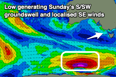
Unfortunately, following later Saturday's change, strong S/SW winds will move in, spoiling a moderate sized S/SW groundswell. The low generating this swell isn't overly impressive, with a quick burst of severe-gale W'ly winds due to be generated on the polar shelf, producing a kick to 4ft on the Surf Coast and 6ft to the east. There'll also be some localised windswell from the strong S/SW winds, with both easing Monday as winds shift more S/SE.
Moving into Tuesday, strong S/SE winds will continue to create poor conditions, shifting SE on Wednesday and bringing another dose of SE windswell.
It doesn't look like winds will ease off until later in the week now, but we'll have a closer look at this on Friday.
Comments
Damn, that High in the Bight early next week is pure evil.
Feels like it's been like this almost every day since early September. Any chance of this pattern fucking the fuck off?
For supposed El Nino it's got a very La Nina feel - there's lots of rain up the east coast, and we are filled with southerlies.
I distinctly remember stepping outside on the weekend and just loving the stillness which felt like we haven't had for weeks on end. Surf aside it just lightened my mood. Spring is such a prick time of year, offers nothing to anyone unless you love horses.
Baby birds too - there's quite a lot just leaving the nest right now, look for the little fluffy fellas learning to fly.
Spring isn't bad for bushwalking.It is nothing special for surfing . These Spring southerly winds seem to be never ending. I start frothing for surfing in Late February until the ski season starts.
Hey Craig, any chance this reign of onshores goes away by 30-2nd?