Building surf from tomorrow afternoon with workable winds

Victorian Surf Forecast by Craig Brokensha (issued Wednesday September 27th)
Best Days: Tomorrow from late morning to mid-late afternoon, Friday morning, Saturday, Monday exposed beaches
Features of the Forecast (tl;dr)
- Low point in swell tomorrow AM ahead of building mid-period energy into the afternoon
- NW tending variable winds tomorrow ahead of late sea breezes
- Inconsistent W/SW groundswell Fri with mod-fresh N/NW tending variable winds ahead of a shallow S/SE change
- Easing surf Sat with strengthening N winds, easing later
- Smaller Sun with N/NW tending S/SW winds
- Small pulse of windswell Mon with N/NE winds
- Small surf Tue with N/NW tending W/NW winds
Recap
The surf kicked in size yesterday with a mix of long-range and mid-period energy offering 3ft waves across the Surf Coast, 4ft to the east. Variable winds through the morning created workable conditions ahead of freshening sea breezes into the afternoon.
This morning the swell has lost a bit of energy and early light winds on the Surf Coast are offering lumpy conditions that will deteriorate as winds strengthen from the SW-S/SW over the coming hours.
This week and next (Sep 26 - Oct 6)
The surf will continue to ease back into tomorrow morning, reaching a low point but still likely coming in at 2ft on the sets across the Surf Coast magnets and 3ft+ to the east as winds shift back to the NW. They’ll tend variable into the afternoon ahead of weak, late afternoon sea breezes.
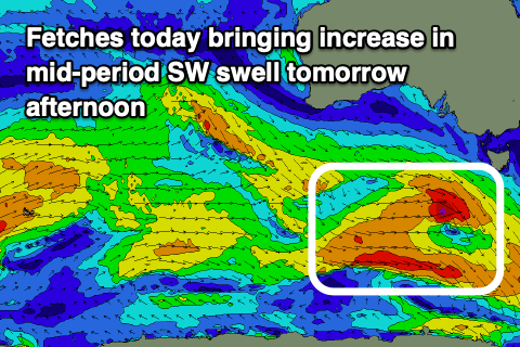
We should start to see some new mid-period swell energy building after lunch, associated with the remnants of a strong frontal progression that will generate an inconsistent W/SW groundswell for Friday.
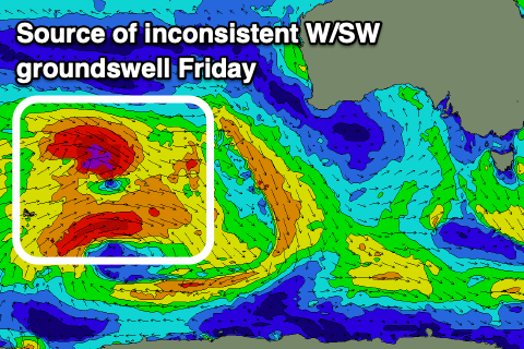
That being pre-frontal fetches of strong W/NW winds under the country today. A slight kick to 2-3ft is due later tomorrow on the Surf Coast, 4-5ft to the east, ahead of the inconsistent groundswell that was generated by distant, gale to severe-gale W/NW winds, north-east of the Heard Island region on Monday.
This groundswell will be slow with long waits for the sets but we should see 3ft to occasionally 4ft waves on the Surf Coast magnets, 4-5ft+ to the east, then easing from 3ft and 4-5ft respectively on Saturday.
Conditions on Friday will be be best through the morning thanks to a moderate to fresh N/NW offshore, tending variable around midday ahead of a trough and shallow afternoon S/SE change.
Come Saturday both regions look decent with strengthening N’ly winds that should tend N/NW at times across the Surf Coast and ease through the afternoon.
Sunday will become smaller and morning N/NW winds will give into a fresh SW change around midday as a trough pushes through, so aim for a morning paddle.
Moving into early next week, and a very weak fetch of W/SW-SW winds trailing Sunday’s change will produce a small kick in windswell for Monday but not topping 2ft on the Surf Coast and 3ft+ to the east. Winds will shit more favourable for the beaches and N/NE offering OK waves for the desperate.
Tuesday looks to be a lay day as a trough brings another change through the middle of the day along with easing surf from Monday.
Into the middle to end of the week, small to moderate, inconsistent levels of W/SW groundswell are due to arrive, generated by a strong, slow moving frontal progression firing up towards Western Australia over the weekend and early next week.
Size wise, nothing major is due, with moderate levels of swell expected Thursday though winds look dicey as the remnants of the progression push east, bringing strong S’ly winds. The models diverge around this though so check back here on Friday for the latest.
Comments
G'day Craig, great to have you back. Do you have any insights into why the CapeS buoy has been putting out such weird data lately? Been checking it periodically over the last couple of weeks and it'll graph out changes on straight acute angels... Almost looks like there are gaps in the data range and it just draws lines between the two most recent readings.
Interesting, looks like the buoys transmitter or battery might be on the way out. Might need a replacement..
no worries, i'll paddle over and whack in a coupla AAAs
Only a guess but i think they are outages - CDC buoy does this sometimes as well
Yep. Looks like a deteriorating issue as well.