Fun weekend, large swell for early next week

Victorian Surf Forecast by Craig Brokensha (issued Wednesday December 21st)
Best Days: Keen surfers Friday morning Surf Coast, Saturday morning Surf Coast, exposed beaches Sunday and Monday mornings, selected spots Monday afternoon and Tuesday, Wednesday morning
Features of the Forecast (tl;dr)
- Moderate sized, inconsistent SW groundswell building Fri, peaking in the PM, easing Sat
- Moderate W/SW-SW tending fresh S/SW winds Fri, W/NW tending S/SW Sat
- Fun mid-period SW swell building Sun with NE tending SE winds
- Easing surf Mon AM with NE tending SE winds
- Large W/SW groundswell building strongly Mon PM, easing Tue with E tending SE winds
- Smaller Wed with local offshore winds ahead of a S/SW change
Recap
Weak levels of SE windswell and background SW swell to 2ft across both regions, best on the beaches to the east for the keen.
This week and next (Dec 22 - 30)
The recent, small surfable waves seen across the exposed beaches will fade into tomorrow, making it a lay day.
A weakening mid-latitude trough moving in from the west will see E/NE winds persist tomorrow morning, though shifting E/SE-SE into the afternoon ahead of a SW change early Friday morning.
This trough looks to mess with a good new SW groundswell that’ll be on the build Friday, with moderate W/SW-SW tending fresher S/SW winds due to develop through the day. The chance for an early W’ly on the Surf Coast looks slim and the swell will be a bit smaller early.
The source of the new groundswell was a strong though distant frontal progression that developed around the Heard Island region over the weekend.
We should see inconsistent sets building to 3ft+ on the Surf Coast magnets into the afternoon with 4-5ft+ sets to the east.
The swell should ease into Saturday morning but sets to an inconsistent 3ft are due to continue on the Surf Coast magnets, with 4-5ft sets to the east and winds will become more favourable. An early-mid morning W/NW breeze is due across the Surf Coast, W/SW-SW elsewhere and then tending S/SW through the day across all locations.
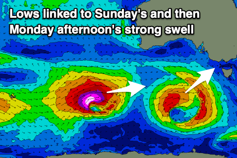
Into Sunday we should see a fun new mid-period SW swell filling in, generated by a strengthening low south-west of Western Australia this evening.
A tight but good fetch of strong to gale-force W/SW winds should generate a fun pulse of energy that’ll arrive late morning and build to 3ft+ across the Surf Coast and 4-5ft to the east into the afternoon. Winds look great for the beaches and NE during the morning but sea breezes will kick in by midday, adding bumps as the swell fills in.
Monday morning looks clean again for the beaches with a NE offshore and drop in size from Sunday afternoon.
Now, moving into the afternoon and evening, a large long-period W/SW groundswell is expected to arrive, building towards a peak overnight, then easing Tuesday.
The source of this swell will be a significant, ‘bombing’ low forming to the south-west of Western Australia. A ‘bombing’ low is one which drops at least 24hPa within a 24 hour period and this will do so during Friday.
As a result, we’ll see a significant fetch of storm-force W/SW winds projected east towards us, weakening once pushing under the country through Sunday and then dipping away to the south-east.
With the eastward projection and likely captured fetch scenario, we’re looking at a rapid, large increase in size later Monday, pushing to 6ft+ on the Surf Coast magnets and 8-10ft to the east, peaking overnight and then easing from 4-5ft+ and 6-8ft respectively.
Winds on Tuesday look a little funky and might be out of the E, though light, giving into SE sea breezes, with smaller surf due Wednesday under possibly local offshore winds (N/NE Mornington Peninsula, N/NW Surf Coast).
Longer term we may see a surface trough deepening to our east, bringing a junky SE windswell, but more on this Friday.
Comments
Thanks Craig, good Christmas present, haven;t been in for a week at least!
Merry Christmas to you and the team, love these notes, the website and the great job you do
Thanks for the kind words PL. You too!
Boxing day + warm temps + people on holidays + building swell due to bombing low = very busy surf lifesavers
Very good point. It has all the ingredients for disaster.