Great week for the beaches

Victorian Surf Forecast by Craig Brokensha (issued Monday 7th November)
Best Days: Beaches tomorrow morning, Wednesday, Thursday, exposed beaches Sunday morning, Surf Coast next Tuesday
Features of the Forecast (tl;dr)
- Small pulse of mid-period SW swell for tomorrow PM, holding Wed AM, then easing
- Light-mod N/NE tending E/SE-SE winds tomorrow
- Local offshore winds Wed, freshening from the NE later AM, possibly tending E/SE for a short period mid-late PM
- Moderate sized mid-period SW swell building Thu PM, holding Fri with a reinforcing stronger pulse into the PM, easing Sat
- Strengthening N/NE winds Thu, moderate S/SW Fri
- Easing surf Sat with SE winds
- Smaller Sun with N/NE tending SE winds
- Moderate sized mid-period SW swell arriving late Mon next week, peaking Tue with gusty W/NW tending W/SW winds
Recap
Friday's solid mix of swell energy eased back slowly through the weekend, a bit too big for the beaches on Saturday to the east, decent across selected Surf Coast spots, while a final reinforcing pulse of inconsistent SW groundswell arrived later in the day, holding yesterday morning.
Conditions were clean across all locations yesterday morning with easing 3-4ft sets on the Surf Coast, 4-6ft to the east.
Today we've got a fading swell but great waves on the exposed beaches, coming in at 3-4ft, with the Surf Coast coming in around 2ft mostly with the odd 3ft'er on the magnets.

Tasty surf this AM
This week and weekend (Nov 8 - 13)
We've got a great week of waves on the cards with light winds and options opening up across both regions, biggest into the end of the week.
The beaches will be the pick over the coming days with a new pulse of mid-period SW swell due to fill in tomorrow afternoon, holding Wednesday morning.
The source was a weak frontal system moving in behind all the activity linked to late last week and the weekend's swells, with tomorrow morning likely to be in the 3ft range on the Mornington Peninsula, increasing to 3-4ft through the afternoon, holding a similar size Wednesday morning. The Surf Coast looks to be smaller and in the 2ft range.
A N/NE offshore will create great conditions on the Mornington Peninsula and across Phillip Island with variable N-N/NW winds on the Surf Coast before E/SE-SE sea breezes kick in.
 Wednesday morning looks similar with light, local offshore winds, freshening from the NE later morning and possibly only reverting to the E/SE temporarily through the mid-late afternoon.
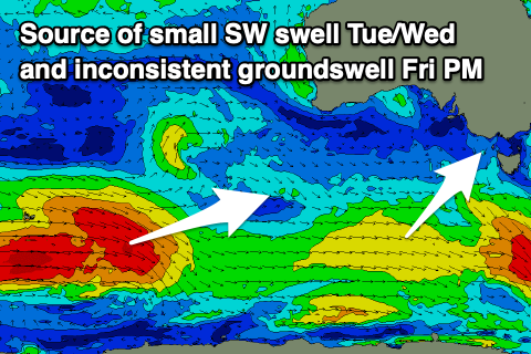
Into the end of the week, a better mid-period SW swell is due, generated by a slightly stronger polar frontal system that's currently south-southwest of Western Australia.
Yesterday this front was generating gale-force winds in our far swell window, but it's now weaker and will continue to decay while tracking east today and tomorrow. This will result in mid-period energy arriving Thursday ahead of the stronger, more groundswell sets into Friday afternoon.
On Thursday, building sets to 4-5ft are due across the exposed beaches into the afternoon, holding a similar size but with less consistency on Friday (idd 6ft bomb likely into the afternoon). The Surf Coast should see 2-3ft sets on the magnets, while the stronger pulse for Friday afternoon coming in more around 3ft+ on the magnets.
Winds will strengthen from the N/NE on Thursday and hold all day as a weak mid-latitude low pushes in slowly from the west, squeezing a high in the southern Tasman Sea.
The low will weaken through Thursday evening while moving across us, bringing a shallow evening S/SW change that looks to unfortunately linger into Friday. There's a chance winds go more variable Friday morning but check back here Wednesday for a clearer idea on this.
Into the weekend we're due to see easing surf and winds shifting SE on Saturday before better N/NE winds kick in on Sunday. Size wise, the Surf Coast looks to be easing from 3ft on Saturday, small to tiny Sunday with the beaches to the east easing from 4-5ft Saturday and then 2-3ft on Sunday.
Longer term a healthy polar frontal system should generate a moderate sized pulse of mid-period SW swell for early next week with winds from the western quadrant. More on this Wednesday.
Comments
Can’t remember a forecast like this for a very long time :-0
I feel my stoke levels are at a 3 year high. Super fun swells, either glassy or well groomed ocean for hours each day and heat in the sun for days on end. There's been better/bigger surf for sure (although Saturday was solid!), but all these things combined and in Spring of all times has me feeling good.
Keep it coming huey...