A Victorian winter resurrection (coming soon!)

Victorian Surf Forecast by Ben Matson (issued Wednesday 26th October)
Features of the Forecast (tl;dr)
- Poor surf Thurs/Fri
- Fun window of small clean though windy surf west of Melb on Sat
- Open beaches looking OK Sun with winds becoming light, maybe N'ly later
- Steadily building surf next week; the second half thru' into the weekend looking like a return to absent winter form
Recap
Easing SE windswell on Tuesday offered OK conditions west of Torquay into the afternoon, with size easing from 3-4ft to 2-3ft, as winds became light and variable. Surf size was smaller east of Melbourne, a rare occurence though expected with the swell direction. Unfortunately lingering onshore winds (west of Melbourne) and a more rapid than expected decline in swell size resulted in poor offerings today, with only a few spots east of Melbourne having small clean peelers this morning, before winds swung onshore this afternoon.
This week (Oct 27 - 28)
Pretty much nothing of interest for the rest of the week.
Thursday will be between swells, along with freshening westerly winds as a low pressure system develops just to our west. All coasts will be tiny.
There's a chance for a tiny spread of S'ly swell into the Surf Coast, from a S/SW fetch off Tasmania's West Coast today, but I don't think it'll amount to much, the angle is too acute and the fetch length too short.
The developing low will move east on Friday, resulting in a strengthening NW tending W'ly flow, and an eventual kick in short range swell thanks to the trailing SW fetch (on the low's western flank) pushing through Bass Strait into the afternoon. However surf size will start off very small, and the afternoon's increase will be accompanied with gusty cross-onshore (Surf Coast) thru' onshore (East Coast) winds, resulting in low quality everywhere. There'll be some new groundswell building in the mix too (discussed below), but it won't provide enough size for sheltered spots.
So, fuggedaboutit.
This weekend (Oct 29 - 30)
The models have made a few tweaks to the weekend forecast, but I still think there'll be a fun window of waves early Saturday.
We'll see two swells in the water, some post-frontal windswell plus an underlying groundswell sourced from a strong front that tracked east of Heard Island over the last few days. The long travel distance will result in significant waits between the sets, but we're looking at a combined size around the 3ft mark across the Surf Coast's swell magnets.
Local winds are still expected to be generally W/SW, however we've now got a better chance for the early window of W/NW breezes thanks to a short wave feature (read: front) that'll approach from the west in the morning. I'm unsure on the timing of its passage into Bass Strait - and thus the swing in the wind direction - so earlier will be better. Let's firm up things on Friday.
East of Melbourne, expect blown out conditions at the open beaches on Saturday and small slow waves inside Western Port at best (not worth your time and effort, to be honest).
This second front should clear to the east through the night, allowing for light variable winds Sunday, possibly tending northerly as a pre-frontal trough approaches from the west. But, we'll be on the backside of the swell event so expect small surf west of Melbourne, and chunkier options at the open beaches east of Melbourne. Shouldn't be too bad on most coasts to finish the weekend.
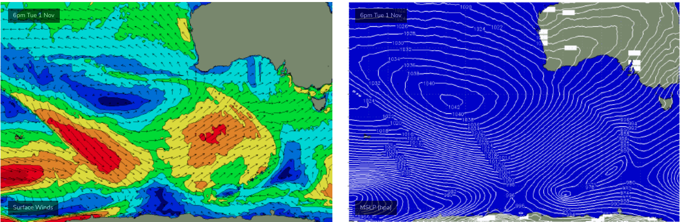
Next week (Oct 31 onwards)
Yep, we've got a whole stack of surf due next week, as a Long Wave Trough amplifies across the entire southern expanse of the continent.
It's still a little early to pin down specifics, but early indications are for all-week-westerlies (alright!), and surf prospects kicking off with a initial small spread of small swell from a poorly aligned front pushing up into WA from the weekend onwards.
This will be followed by a series of better, stronger swells from the SW and S/SW as the storm track charges nicely through out primary swell window (see below) with a series of back-to-back polar lows and fronts.
It's still early days right now, but the second half of next week (and potentially the weekend) is shaping up for a classic winter pattern with pendulating winds from the western quadrant, and solid surf that should push well north of 6ft in Torquay for a day or two.
Let's wait and see how Friday's model runs hold out, eh? Fingers crossed.
Comments
Thanks Ben. Get rid of that Craig bloke.
Oh goody!
Thanks Ben for answering that question about the little swell going up west coast of Tas, too.
At last my wave has come along and my days with flat onshore shyte are over... or are they?
"back-to-back polar lows and fronts"
This fills me with nostalgia....a feeling I use to associate with surfing in Victoria.....a feeling which was seemingly long ago replaced by the terms 'blockin high' and 'unseasonably strong south east winds'.
the Thermalben effect strikes once again!
Hopefully the winds co-operate when we get the swell, not just large and bumpy/wonky which is often the case. Would love to see some groomed lines. I live in hope.
Well it's mid-July weather for the foreseeable so you may get lucky.
Well I'd also love to see some groomed lines from this aboveformentioned swell Thermalben. Slighly disappointed by the latness of today's update forecast TBH. I normally have a surf during the middle of the day on Friday at Urbansurf on the expert setting and then have a latte at the 3 Purple Ducks and read the Friday Forecast Notes - once again I've missed out due to the tardiness of the Notes.
Don't suppose you've got anything better to do thermzy? Would love an updated set of notez for today
You still sleeping thermsy? After the worst winter in history this is just salt in the wounds
yeah, a whole long weekend to pattern !
These late report drops do absolutely nothing for my work productivity as I constantly flick back to SN hoping that Ben has decided not to leave Vicco to last again... we've suffered enough!
No need to harass Ben, I'm sure he will have some good news for us.
Sorry lads, been a mental day. Will have the FC notes through in about 45 min.