Meh weekend of surf, not much better next week

Victorian Surf Forecast by Craig Brokensha (issued Friday 11th June)
Best Days: Beaches today, Wednesday on the beaches, possibly early Thursday
Features of the Forecast (tl;dr)
- Easing, inconsistent SW groundswell tomorrow, further Sun
- Fresh W/SW winds tomorrow (W/NW in the AM Surf Coast), W/NW tending variable Sun
- Inconsistent W/SW groundswell for Wed with NE tending E-E/SE winds, easing Thu with variable tending fresh SW winds
- Mod-large, inconsistent SW groundswell filling in Fri with fresh S/SW winds
Recap
Large, stormy and relatively mild temperatures yesterday as warm air wrapped in from the Tasman Sea, into the southern flank of the board low sitting to our east. Conditions were poor right until dark when winds abated to the east, while today we've got much better conditions with a light E/SE breeze.
A mix of fading SE windswell and inconsistent SW groundswell are providing average, lumpy 2-3ft waves on the Surf Coast, best on the beaches, while the Mornington Peninsula is better with peaky 3ft+ surf.
This weekend and next week (Jun 12 - 18)
Down, down down.
That's the outlook for the weekend and early next week ahead of a new swell Wednesday.
The reason for this is that the broad, stalling low across the south-east of the country combined with a high to our west has put a block across our close-medium range swell windows.
The current windswell from the last couple of day's onshore winds will fade tomorrow, leaving an inconsistent, long-range SW groundswell, which will also be on the ease.
Expect inconsistent 3ft to possibly 4ft sets on the Mornington Peninsula tomorrow morning, smaller into the afternoon and back from 2ft to possibly 3ft Sunday.
The Surf Coast will be 1-2ft max tomorrow, tiny Sunday and winds will only favour protected spots. A fresh W/SW breeze is due tomorrow morning (W/NW in the morning on the Surf Coast), light to moderate W/NW tending variable Sunday afternoon. The beaches will be best into the late afternoon but small.
Into next week we're looking at clean conditions under light N'ly winds Monday, N/NE tending NE on Tuesday but with no swell. The Surf Coast will be tiny and the Mornington Peninsula beaches 2ft max.
Of greater importance is the new, inconsistent W/SW groundswell due into Wednesday.
This swell which might show on dark Tuesday will be generated by a distant frontal progression that's currently north of the Heard Island region.
A great fetch of strong to gale-force W'ly winds are being aimed through our western swell window, with a secondary intensification of W/SW gales due to fire up south-west of Western Australia this afternoon and evening, breaking down tomorrow.
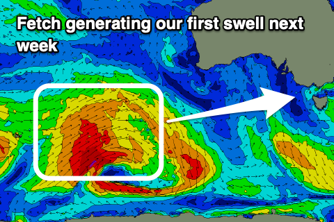 A fun though inconsistent W/SW groundswell will be generated, arriving very late Tuesday but peaking Wednesday to 2-3ft on the Surf Coast and 4-5ft on the Mornington Peninsula.
Conditions will be great for the beaches in the morning with a moderate NE breeze, shifting E-E/SE into the afternoon. Thursday looks dicey as a trough moves in from the west bringing a SW change ahead of early variable breezes.
This trough isn't due to bring any swell with it, but it will spawn off a stronger polar low which will fire up Sunday night initially in our far swell window before pushing closer next week.
A pre-frontal fetch of W/NW gales will give way to stronger severe-gale to storm-force W/SW winds, south-west of Western Australia, then weakening once moving under the country.
This should generate a moderate-large, long-period SW groundswell for Friday, building through the day and peaking into the afternoon. Unfortunately the trough looks to linger into Friday bringing fresh S/SW winds, possibly cleaner into Saturday but we'll have to review this next week.
Size wise the Surf Coast should build to 3-5ft with 6ft to possibly 8ft sets on the Mornington Peninsula. More on this Monday. Have a great weekend!
Comments
Another poor forecast. I hope it isn't turning into a sick rerun of last winter on the SC. Hey Craig, what are the drivers of the local climate like SAM etc indicating? Is it possible to tell if we are in for a more 'normal' winter pattern?
I don't know what makes me more anxious, the prospect of a repeat of last year's swells / lack of, or lockdown V5.....
Was looking a bit deeper into this late last week as well. Latest update here and will keep digging but it's due to a persistent splitting jet stream across the country, though why? https://www.swellnet.com/reports/forecaster-notes/victoria/2021/06/14/fu...
Split jet stream is Huey's way of giving Victoria an extra hard wedgie when it's down.
Meh
Wake me up when the 25 km travel rule ends.
Don't whinge Melbourne surfers, Port Phillip Bay must have had the best surf in the state all week and none of us coasties could get there due to lockdown laws.
Any reports up St Kilda way during that storm?
Don't forget we can't even go up to the Puddle.
And for meh I had an absolute ball out there today - small perfect shaped little peelers. Horses for courses.