Another week of swell before quietening down

Victorian Surf Forecast by Craig Brokensha (issued Monday 19th April)
Best Days: Today, Tuesday morning Surf Coast, late Thursday Surf Coast, Friday and Saturday protected spots, early Sunday Surf Coast
Features of the Forecast (tl;dr)
- Easing SW groundswell tomorrow with fresh to strong N/NW winds ahead of a late morning, strong SW change
- Weaker mix of swells Wed with a W/NW breeze
- Building SW groundswell Thu PM with gusty NW tending W winds
- Large SW groundswell for Fri with W/NW winds, tending W/SW-SW into the afternoon
- Easing large SW groundswell Sat W/NW winds, tending W/SW-SW late afternoon
Recap
What a great weekend of surf! Friday's reinforcing pulse of S/SW groundswell continued to provide 3-5ft waves across the Surf Coast Saturday with good winds for most of the day, while our reinforcing, new SW groundswell for yesterday filled in keeping most breaks around 4ft with larger waves on the swell magnets.
To the east protected locations were best.
Today the surf is hanging in there around a similar size to yesterday with the secondary pulse of reinforcing SW groundswell (5-6ft on the Surf Coast magnets) and offshore winds.
This week and weekend (Apr 20 - 25)
Our recent run of great surf will back off a bit in size and quality over the coming days, with a drop in size due tomorrow back from 3ft+ on the Surf Coast and 4-5ft+ to the east along with a tricky, fresh to strong N/NW breeze. A strong SW change is due late morning, writing off the surf for the day.
There isn't expected to be any real decent swell in the wake of tomorrow's change with 2-3ft sets on the Surf Coast swell magnets, 3-5ft to the east with a morning W/NW, likely holding into the afternoon.
Looking at the 'bombing' low that was discussed last week, and today the low is doing so, dropping 24hPa within 24 hours but the structure has changed since.
What we'll see is is an initial burst of pre-frontal gale to severe-gale NW winds this evening and tomorrow, generating a small pulse of SW groundswell for Thursday afternoon. Winds will shift from a gusty morning NW'ly in the morning to the W into the afternoon with 2-3ft sets likely int the afternoon on the Surf Coast.
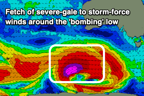 Of greater significance is a fetch of trailing severe-gale to storm-force W/SW winds projecting favourably east-northeast towards us, breaking down as a secondary front fires up its tail, generating an additional fetch of W/SW gales.
We'll see a large, long-period SW groundswell from the initial strongest fetch arriving overnight Thursday, peaking Friday with 6ft to occasionally 8ft sets on the Surf Coast magnets, 8-10ft to the east. Winds look great for protected spots and fresh from the W/NW in the morning, W/SW into the afternoon.
The secondary front should keep the swell large into Saturday morning with 4-6ft sets on the Surf Coast swell magnets, 6-8ft to the east along with a W/NW offshore, holding into the early afternoon and possibly W/SW-SW late afternoon.
Smaller surf is due Sunday but with less favourable SW winds, likely W'ly early on the Surf Coast.
Longer term out active period of solid surf will wind down with smaller, mid-period S/SW swells on the cards into early next week, but more on this Wednesday.
Comments
Looking forward to seeing Craig’s forey today
Please don't show us ya forey, craig.
Goofy can play with his own.