Good swell early week, though not the winds

Victorian Surf Forecast by Craig Brokensha (issued Friday 2nd April)
Best Days: Beaches for the keen tomorrow morning, Monday for those with lowered expectations, selected spots Tuesday morning, Wednesday morning on the beaches, Thursday
Features of the Forecast (tl;dr)
- Building mid-period SW swell Sun PM, stronger and peaking Mon, easing slowly through Tue and Wed
- Light W tending fresher S/SW winds Sun, light to moderate S/SW tending S Mon, SE-E/SE Tue AM and E/NE Wed AM
Recap
Clean, small and fun waves across selected beaches both east and west of Melbourne yesterday and the same today. We'll see conditions remain favourable most of the day for locations east of Melbourne, with only a brief late afternoon SE breeze likely.
This weekend and next week (Apr 3 - 9)
Tomorrow should be similar in size again across both coasts with 1-2ft sets on the Surf Coast swell magnets and 2-3ft sets to the east and winds will freshen, locally offshore and N/NE winds east of Melbourne in the morning, N/NW to the west, holding most of the day.
Winds look light and variable out of the W Sunday morning in the wake of a shallow change Saturday evening, though we'll see winds shift more S/SW and slowly increase through the day as the first signs of mid-period SW swell start to build.
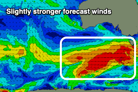 The frontal progression linked to our coming swell (which looks to be a bit better than mid-period energy but not proper groundswell) is currently starting to develop south-west of Western Australia.
An initial weak, though broad front will strengthen while pushing east under the country this evening, with a good fetch of strong to gale-force W/SW winds due to be projected through our south-western swell window, followed immediately behind by a slightly more consolidated fetch of W'ly gales tomorrow evening and Sunday.
We'll see building mid-period energy through Sunday from 2ft+ on the Surf Coast to 3ft+ through the afternoon, 4ft to the east and reaching 5-6ft late.
Monday looks a bit stronger now with the peak in swell coming in at a fairly consistent 4ft on the Surf Coast magnets, a consistent 6ft to the east, with possibly the odd bigger one.
Unfortunately winds still look less than ideal but in saying this they'll be workable with a light to moderate S/SW tending S'ly breeze. Keep your expectations low and you should find a couple of keepers.
Tuesday will be average on the Surf Coast with a moderate SE'ly as the swell eases from 3-4ft, a bit better in selected spots to the east with a light E/SE breeze and easing 5-6ft sets.
Wednesday and Thursday look the pick on the beaches with an E/NE breeze on the former, N/NE early on the later, shifting W/NW ahead of a SW change. The swell will continue to ease, though slowed by continued polar frontal activity on the back of the main progression this weekend.
The Surf Coast should ease from 2-3ft across the swell magnets Wednesday morning 4ft+ to the east with smaller surf Thursday.
Longer term the outlook is still tricky as we'll see a tropical cyclone off the North West of WA likely drifting south to mid-latitudes, throwing a few spanners in the works. Check back here Monday for a clearer idea on next weekend and beyond. Have a Happy, Safe Easter!
Comments
Looking fun east of Melbourne.

The tide shifts down here are wild at the moment.
Happy Easter to all the team. Had a quick couple of questions about the addition of the SD obs for the CS and CDC buoys. Is there much relevant data / info that can be taken from these obs? And if so what is the best way to read the data? Haven’t paid much attention to them in the past