Poor couple of weeks of surf

Victoria Forecast by Craig Brokensha (issued Monday 22nd June)
Best Days: Desperate surfers Wednesday mid-late morning, Saturday
Recap
Inconsistent and small waves to start off Saturday, 2-3ft on the Mornington Peninsula with OK conditions, 1-2ft and clean on the Surf Coast. A new mix of swells kicked into the late afternoon and peaked Sunday with fun 3ft sets on the Surf Coast, 4-5ft to the east and with generally clean conditions.
Today the swell has eased and the Surf Coast is cleanest with small, 2ft waves.
This week and weekend (Jun 23 - 28)
The coming week (and beyond) is still looking average for surfing across the state.
A broad low that's been sitting west of us all weekend is now slowly moving east and we'll see it extend its western arm into us early tomorrow morning, bringing strong S/SE winds and with no new swell, poor surfing conditions. A localised mix of leftover swell from today and windswell are expected, and winds are due to ease and tend more S/SW into the late afternoon.
Wednesday's change in swell direction to the W/SW isn't expected to offer any real new size, with it generated in our far, far swell window, south-east of Madagascar. Conditions should improve across the beaches with a more variable E'ly breeze developing through the morning but only expect very inconsistent 3ft+ sets max on the Mornington Peninsula. The Surf Coast will likely be very slow and to 1-2ft.
A swing in winds to the N/NW tending W/NW are due Thursday as the small, inconsistent W/SW groundswell eases, not favourable for any location.
The change in wind direction on Thursday is linked to a weakening mid-latitude front pushing in and east-southeast across us, with some small mid-period swell due from the earlier stages of this system.
It's not a great swell and very west in nature, produced by a mid-latitude low slipping south of WA and stalling tomorrow while generating a fetch of strong W/SW winds through our swell window. the swell should build Friday from a tiny base, reaching a small and slow 2ft to possibly 3ft on the Surf Coast, 4ft to occasionally 5ft to the east, then easing from a similar size Saturday.
Winds won't be too favourable as the swell builds Friday afternoon and onshore from the S/SW, with Saturday the best as winds tend back to the N (N/NW-NW Surf Coat) and hold into the afternoon.
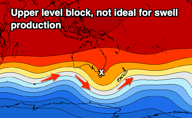
Longer term the outlook remains poor with an upper block setting up camp just east of Tasmania which is opposite to a node of the Long Wave Trough. One such node will move in slowly under WA early next week though no major swell potential is slated for us at this stage. Check back over the coming updates on when we may see a more winter-like outlook moving back in.