Wintery swells to end the week

Victoria Forecast by Craig Brokensha (issued Wednesday 6th November)
Best Days: Protected spots tomorrow and Friday morning, early mornings Surf Coast Saturday and Sunday, exposed beaches Monday
Recap
Persistent levels of mid-period W/SW swell yesterday coming in between 2-3ft on the Surf Coast magnets but on the weak side, cleanest in protected spots which were smallest, bumpy to the east. Conditions improved into the late afternoon on the Mornington Peninsula though as winds eased and tended more variable.
Today the swell was expected to be on the ease, but the Surf Coast magnets were seeing a bit more strength and consistency with 3ft sets, smaller and around 2ft+ around Torquay, bumpy to the east.
This week and next (Nov 7 - 15)
Now that the smaller stuff is done with, we look to an out of season run of westerly winds and larger, windy swells, all linked to the Sudden Stratospheric Warming event a couple of months ago, and the flow on effects.. that being a strong negative Southern Annular Mode (SAM).
If short, the negative SAM event is lifting the westerly storm track further north than normal bringing the coming run of wind and weather.
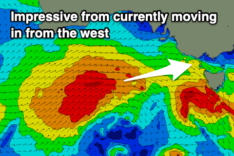
Currently a strong mid-latitude front is moving in from the west, with it just south of the Bight, generating a fetch of W/SW gales. This is following the earlier stages of the storm, that being an intense low south-west of WA, generating a fetch of severe-gale to storm-force W/SW winds.
We'll see the front moving in and across us later this afternoon, with a slight upgrade in the size expected from dawn tomorrow morning.
 A mix of W/SW groundswells should be seen filling in tomorrow, with the peak in size now hard to pick but the morning should see 3-5ft waves on the Surf Coast magnets, 6ft+ to the east, with the afternoon likely more towards a consistent 4-5ft and 6-8ft respectively.
Conditions will be great in protected spots all day with a fresh to strong W/NW breeze, likely tending NW at times on the Surf Coast into the afternoon.
Friday morning will be good as well with a moderate W/NW-NW offshore, shifting W/SW late morning ahead of a stronger S/SW change into the afternoon. Size wise, the Surf Coast should ease back from 3-5ft, with 6ft+ sets to the east.
The easing trend will be slowed into Saturday as a weaker trailing mid-latitude front and polar front behind the current storm generate strong W/SW and S/SW fetches in our swell window. This and a third front moving in through the day, strengthening through Bass Strait.
The Surf Coast should hold around 3-4ft, but the energy will be more windswelly and much weaker and conditions not too flash. Winds look gusty out of the W/SW, strengthening through the day, with a dawn W'ly breeze around Torquay.
Sunday morning might be the better pick with a more prolonged morning W/NW breeze around Torquay and easing mid-period SW swell from 3-4ft, 6ft to the east but a mess.
There's one window for good conditions across the exposed beaches on the Mornington Peninsula and that's Monday. In between another strengthening mid-latitude storm in the Bight, we'll see winds go offshore from the N/NE through the day. Sunday's swell will continue to ease from 2-3ft on the Surf Coast and the 4ft range to the east. Both models are in line regarding these more favourable winds, but we'll confirm it Friday.
The models diverge on the following mid-latitude storm forming in the Bight though, with EC having a south-east to north-west angled trough and no real swell, while GFS has a much more significant system and moderate to large sized W/SW swell. With this divergence we'll have to review the outlook on Friday.
Comments
Forey exposed before 9am. Solid effort!
Haha, and while I'm still editing the text. Enjoy.
Already waxing up 2 options for tomorrow Craig....I really hope it's also got some winteresk power......
Craig loves whipping out the forey while people are still having breakfast.
Plop it right in their Coco Pops Craig.
"Cop a load of this little beauty!"
Meanwhile, the people inland have had a November white Christmas
https://www.willyweather.com.au/news/10674/hailstorm+hits+riverland%2c+l...
OK, it's hail, probably not too nice for the fruit.
Surf wise, the westerlies have been OK (for this bit of coast), very blustery at present. Been trying to surf each day and enjoying a little board. 2ft+ each day, a bit of shape. Colder than you'd expect, so fluffy 3/2 being used. There's been a bit of a wave every day, although a bit gutless on a couple of the days. Today had a bit of kick (or I was in the wrong spot haha)
Dropping tide and increase in period is providing more consistent and better action around Torquay now.
Definitely winter here today, heavy rain at times, cold and puddles - can we say this is related to how the Stratospheric Warming event was supposed to play out?
Not complaining, love the storms.
Yep looks like it.
Hmmm, larger random waves at times.....yes, with power.....no :( tomorrow morning....maybe? Nice to see some dolphins working the line-up this arvo but there was some other movement beneath the surface...be careful crew.