Good run of offshore winds and fun westerly swells

Victoria Forecast by Craig Brokensha (issued Wednesday 17th July)
Best Days: Surf Coast every day until Monday, locations to the east Friday afternoon and Saturday
Recap
Monday’s large swell eased back a little into yesterday but remained large across all locations through the morning, settling a little into the afternoon. W’ly winds favoured protected spots with the Surf Coast reefs the pick though a little raw.
Today conditions are much cleaner with a great offshore wind and 4ft of swell on the Surf Coast, bumpy and 4-6ft to the east. We’ll see the swell ease off further through the day as winds shift more W’ly.
Today’s Forecaster Notes are brought to you by Rip Curl
This week and weekend (Jul 18 - 21)
These notes will be short as Ben's on annual leave.
The surf will continue to ease into tomorrow, though slowed by a reinforcing mid-period SW swell generated by a front clipping us today. The Surf Coast should hold around 3ft, with 4-5ft sets to the east and a moderate to fresh NW wind will hold all day.
Our W/SW groundswell for Friday and Saturday is still on track, with a strong mid-latitude front that’s currently pushing under WA, generating a fetch of strong W/SW winds, with embedded gales.
We’ll see the swell build in size and power through Friday afternoon, reaching 3ft+ by late in the day on the Surf Coast and likely easing from a slightly bigger 3ft to possibly 4ft Saturday morning. The Mornington Peninsula should build to 4-6ft and then ease from 5-6ft Saturday morning and conditions will improve with a moderate NW tending N/NW breeze on Friday and better but fresh to strong N’ly winds holding all day Saturday.
Wind will shift back to the W/NW tending NW on Sunday along with a new pulse of W’ly swells as a deepening mid-latitude low drops south-east across western Bass Strait.
A burst of W/SW gales might be generated through our swell window, but ECMWF has a much weaker system. I’d expect smaller easing 2-3ft waves on the Surf Coast and bumpy 4-5ft waves to the east.
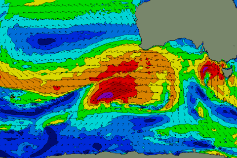 Moving into next week we’ve got a renewal of windy and building mid-period and W/SW groundswell energy as another strong mid-latitude frontal progression moves in from the west.
The frontal progression will be strongest in our medium-range swell window, south-west of WA (pictured right), but we’ll see large surf moving in on Tuesday next week with what looks to be favourable but strong winds from the north-western quadrant. More on this Friday though.
Comments
Excellent! A nice little run to get the paddle fitness back.
Craig how windy Saturday and do you think it will ease quickly? Window on the east coast if it isn't blowing a gale and 6+
Looks 15-20kts and maybe easing a touch later Saturday. Will have a closer look Friday.
Have a look at the 10HPa chart Craig, two stratospheric anticylcones giving SE Australia a giant wedgie above the polar vortex.
Anyone know the details about the guy that had to get rescued from Bells / Winki earlier this week? Saw a headline in the Geelong Tiser but it was blocked by the paywall.