Very tricky period, more reliable from later next week

Victoria Forecast by Craig Brokensha (issued Friday 19th April)
Best Days: Beaches Saturday and early Sunday, Surf Coast late morning to early afternoon Sunday, keen surfers Surf Coast Monday morning, Surf Coast Thursday and Friday
Recap
Good clean conditions on the Surf Coast yesterday morning, but very inconsistent with a new W/SW groundswell and incoming tide. Magnets saw 3ft sets but were very slow, with bigger bumpier waves to the east.
This morning the swell is hanging in there, though a swing in winds to the east are favouring the beaches east of Melbourne rather than the Surf Coast.
A better aligned SW swell should fill in through the day providing 3ft+ sets on the Surf Coast and 5-6ft waves to the east as winds go variable for a period early-mid afternoon and hopefully remain so into the evening.
Today’s Forecaster Notes are brought to you by Rip Curl
This weekend and next week (Apr 20 - 26)
Our mix of W/SW and SW groundswells today will ease off through tomorrow, but winds will continue to improve for the beaches, tending N/NE through the morning, E/SE-SE into the afternoon.
The Surf Coast should see 3ft sets at magnets in the morning, 4-5ft on the Mornington Peninsula. The swell won't ease off too much as a reinforcing W/SW groundswell fills in, generated by a good pre-frontal fetch of W/NW gales ahead of a very intense low during the middle of this week.
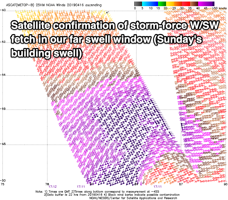 Our tricky, long-period and inconsistent W/SW groundswell for Sunday is still just that, tricky.
The intense low behind the pre-frontal fetch of W/NW gales generated a less than ideal structured and small fetch of severe-gale to storm W/SW winds, with a much better S/SW fetch on its tail, though aimed towards Indonesia.
As a result we'll be looking at an inconsistent and smallish swell on the Surf Coast, bigger to the east.
The groundswell should arrive overnight Saturday and build through Sunday from a small and infrequent 2ft+ at magnets on the Surf Coast, 4ft on the Mornington Peninsula, reaching 3ft and 5-6ft respectively into the afternoon.
Winds will do nearly a full 360 degree swing, with a dawn N/NE breeze due to swing N/NW late morning, and then SW early-mid afternoon.
Therefore try the beaches through the morning as the swell builds for the best waves.
Now, our next tricky W/SW groundswell for Monday isn't less trickier either, but we've got strength on our side.
The remnants of the storm generating the weekend's swells will re-intensify rapidly south of the Bight this evening and tomorrow morning. A fetch of severe-gale to storm-force W/SW to W/NW winds will be generated through our western swell window as the low dips south, weakening through the evening.
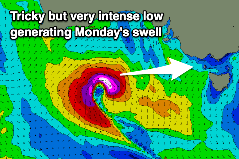 These wind strengths will help generate a significant though short-lived pulse of moderate to large sized W/SW groundswell, arriving overnight Sunday and peaking early Monday. The Surf Coast looks to generally come in around 4ft, if not for 5ft sets at magnets, easing through the day, with 6ft to possibly 8ft sets on the Mornington Peninsula.
Unfortunately winds in the wake of Sunday's change look to linger out of the S'th Monday, moderate in strength, fresher from the S/SE into the afternoon.
More variable breezes may be seen Tuesday morning though from the E/SE-SE and with smaller easing 2-3ft waves on the Surf Coast and 4-5ft to the east. The beaches will be best and the Surf Coast reefs average.
Wednesday will see a low point in swell (NW to SW winds) though from Thursday into next weekend, a series of weak but strengthening zonal fronts should start to generate building levels of W/SW swell. It'll be initially mid-period energy, strengthening to groundswell later week and with favourable W/NW to W/SW winds for the Surf Coast.
It should also be noted there'll be a very long-period signal in the water from late Wednesday and more so Thursday but this is being generated south-east of South Africa in our far far swell window and will have no significant size attached to it.
We'll have a closer look at this on Monday though, have a happy and safe Easter break!
Comments
It’s the vice versa of South Channel recording a seabreeze at the moment; howling on the back beach, glassy on the bay.
Recording 12 knot SW at SC and it’s nigh on glass on the back beaches