Strengthening swells with improving winds

Victoria Forecast by Craig Brokensha (issued Friday 28th September)
Best Days: Torquay early Saturday, Surf Coast Sunday morning, both regions early Monday, beaches to the east Tuesday morning, all spots Wednesday, and Surf Coast Thursday morning
Recap
Much cleaner conditions across the coast yesterday but only small in the morning with fading 2ft to occasionally 3ft waves on the Mornington Peninsula, 2ft on the Surf Coast before becoming tiny into the afternoon.
This morning winds are out of the west and a new weak W/SW swell was starting to show, with more size due later today but with average W/SW winds.
Today’s Forecaster Notes are brought to you by Rip Curl
This weekend and next week (Sep 29 - Oct 5)
This afternoon’s late increase in swell is linked to a broad and relatively weak but sustained cold front moving in from the west the last couple of days, with a peak in mid-period energy due tomorrow out of the W/SW. The swell direction is due to swing more SW into the afternoon owing to a good fetch of winds on the tail of the front in our south-western swell window.
Size wise the Surf Coast should come in generally around 3ft, with the odd bigger one at times at swell magnets, with 4-5ft+ surf to the east.
Conditions are looking fairly average with a moderate to fresh SW-W/SW breeze across most locations, W/NW early around Torquay but it will be a bit raw.
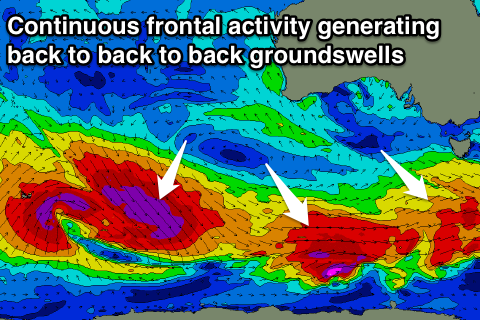 Sunday and Monday are looking much better as our stronger pulses of SW groundswell fill in, generated by back to back pre-frontal fetches of W/NW gales moving in from the south-east Indian Ocean and under the country.
An initial front should produce a good kick in size to 3-4ft on the Surf Coast Sunday afternoon with 6ft sets to the west, while a secondary front moving in on top the active sea state ahead of it will generate the strongest pulse of swell for Monday.
We should see consistent surf in the 4ft range on the Surf Coast and 6ft waves to the east, if not for the odd bigger cleanup.
Now, winds are looking to improve across both regions with a good W/NW offshore Sunday morning, tending SW through the afternoon, while Monday should see local offshore winds - from the N/NW on the Surf Coast and N/NE to the east ahead of a shallow E/SE change owing to a surface trough.
There’s a chance that winds will swing E/SE earlier rather than later so try and surf before mid-late morning just to make sure.
The swell should start to ease into Tuesday and winds will be OK but not great for the beaches and out of the E/NE through the morning, fresh from the E/SE into the afternoon.
The down time won’t be long with another good long-period SW groundswell due to fill in Wednesday ahead of a larger long-period SW groundswell Thursday.
Wednesday’s swell will be generated by a great strong polar fetch of severe-gale W’ly winds, with a kick to 3-4ft and 6ft respectively due as winds swing back to the N’th, but the larger swell looks to be generated by a much bigger low, projecting severe-gale W/NW and then W/SW winds through our south-western swell window.
The only issue with this swell looks to be the local winds as it fills in Thursday, with a surface trough in the region likely bringing onshore SW tending S/SE winds, but we’ll have a closer look at this and the expected size due on Monday. Have a great weekend!