Great tomorrow, very active from late week

Victoria Forecast by Craig Brokensha (issued Monday 10th September)
Best Days: Tuesday, Wednesday afternoon and Thursday keen surfers Surf Coast, Surf Coast Friday onwards
Recap
Fun clean waves in the 2-3ft range across the Surf Coast all weekend, though fairly inconsistent at times, while to the east there was more size but average conditions.
Today, our moderate to large W/SW groundswell is filling in, with pumping waves on the Surf Coast to 4-6ft on the magnets, larger to the east and best in protected spots with a W/NW breeze. We should see the swell peaking through the afternoon as winds remain generally favourable for protected spots.
Today’s Forecaster Notes are brought to you by Rip Curl
This week and weekend (Sep 11 - 16)
Today's strong long-period W/SW groundswell will ease off fairly steadily through tomorrow, slowed just a touch by a reinforcing SW groundswell produced on the backside of the storm that generated it.
A polar fetch of south-east tracking severe-gale W'ly winds were generated in our south-western swell window, with the swell arriving early tomorrow morning.
We should see good easing sets from 4ft on the Surf Coast and still large 6ft+ sets on the Mornington Peninsula, smaller and more manageable into the afternoon. Conditions will be great for more exposed spots with a moderate to fresh N'ly persisting all day to the east of Melbourne, tending N/NW across the Surf Coast.
Wednesday will start smaller and slower and a mid-latitude front that's currently approaching the south coast of WA will ride too high to generate any swell for us until it dips south-east in a much weaker form as it drifts south-east across us on Wednesday morning.
We'll see a burst of strong to sub-gale-force W/SW winds through our western swell window and it's unlikely to generate much in the way of swell for the Surf Coast, with a kick from 2ft during the morning to 2-3ft possibly later (under model expectations), with building 4-5ft sets to the east.
A W/NW breeze will keep the Surf Coast clean, but with the lack of size and power it won't be great.
A drop in size should be seen through Thursday morning with persistent NW winds but some good new W/SW groundswell should be seen into the afternoon and more so Friday ahead of a larger increase on Saturday.
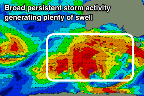 These swells will originate from a broad and elongated frontal progression pushing in from the south-east Indian Ocean through this week, with an initial fetch of W'ly gales tending less favourable from the W/NW on approach Wednesday, generating a new W'ly groundswell for later Thursday and more so Friday to 3ft+ on the Surf Coast magnets and 5-6ft to the east.
A stronger and better aligned W/SW groundswell should then build through the afternoon generated by a more southerly positioned and better aligned fetch of gale to near-severe-gale W/SW winds on top an active sea state.
A moderate to large long-period W/SW groundswell will result, building later Friday likely to at least 4ft by dark on the Surf Coast, 6ft+ to the east and peaking Saturday morning to 4-5ft+ and 6-8ft respectively.
This swell looks to be overridden by an even larger swell into the late afternoon and Sunday though as a third front piggy-backing on top of all this activity projects a fetch of severe-gale W/SW winds directly south-west of us on Friday and Saturday.
The models are slightly divergent on this system, but we're looking at a larger swell with winds form the western quadrant, but more on this and follow up swells on Wednesday.
Comments
Stella conditions across the Victorian beaches this morning..