Tricky winds working around incoming swells

Victoria Forecast by Craig Brokensha (issued Monday 5th June)
Best Days: Surf Coast keen surfers Wednesday morning, Surf Coast Friday morning, east of Melbourne Sunday morning
Recap
Small fun waves on the Surf Coast all weekend, with a little more size to the east, best yesterday morning with a bit more north in the wind.
Today a strong but inconsistent new W/SW groundswell is filling in across the region, with the Surf Coast offering clean 3ft waves, while the Mornington Peninsula was bumpy and around 6ft on the sets.
We should see the swell continuing to build towards 3-4ft this afternoon on the Surf Coast as winds hold from the W/NW.
This week and weekend (June 6 – 11)
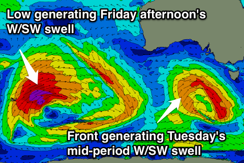
Today's long-range W/SW groundswell was generated by a significant storm in the Indian Ocean and is expected to peak this evening.
A drop in swell should be seen through tomorrow, but a front moving in from the west today will produce some reinforcing mid-period W/SW swell, keeping wave heights steady all day.
 The Surf Coast should hang around 3-4ft with 6ft+ sets on the Mornington Peninsula but fresh and gusty S/SW winds in the wake of the front will create poor conditions across both regions.
Both swells should ease into Wednesday and conditions will improve as winds tend lighter and more variable during the morning. It'll still be average on the Mornington Peninsula, with lumpy conditions on the Surf Coast, but OK waves for keen surfers with easing 3ft sets.
Thursday will be cleaner and straighter on the Surf Coast with a morning NW wind, but the swell small and fading from 2ft. A SW change is due through the day though, linked to a weakening mid-latitude front moving in and under the country.
This front is currently in the form of an intense polar low in the Heard Island region, with a fetch of severe-gale to storm-force W/SW winds being generated in our far western swell window. This system will project nicely towards WA through our western swell window before weakening.
An inconsistent but good sized W/SW groundswell is due from this system, building Friday, peaking overnight and easing Saturday.
The morning will see some mid-period energy from the front passing through Thursday, but we should see the Surf Coast building from 2-3ft during the morning and 4-5ft+ on the Mornington Peninsula, up to an easy 4ft into the afternoon on the Surf Coast (if not for the odd bigger one at swell magnets) and 6ft to occasionally 8ft on the Mornington Peninsula by dark.
The swell should ease back from the 4ft range on the Surf Coast Saturday morning with 6ft+ sets on the Mornington Peninsula, smaller into Sunday.
Winds on Friday will be good for the Surf Coast with a morning W/NW'ly, but the swell will be still developing, with onshore SW winds into the afternoon. Saturday then looks poor as a ridge of high pressure moves in, resulting in S'ly winds, more NE Sunday morning.
The ridge of high pressure will block our swell window for early next week, resulting in no major surf, but more on this Wednesday.
Comments
need to get some floodlights going somewhere so we can do some nightsurfing (yep i can already hear the dissent) - whose got money? :S