Fun weekend, larger W/SW swell for Tuesday, likely spoilt by onshore winds

Victoria Forecast by Craig Brokensha (issued Friday 29th July)
Best Days: Both coasts Saturday, Surf Coast Sunday (east of Melbourne from mid-afternoon), Surf Coast Monday
Recap
Excellent waves across the Surf Coast the last couple of days with clean 3-5ft surf most of yesterday, down a touch to 3-4ft today. Protected locations to the east were best yesterday, while a more favourable N'ly breeze has opened up a few more options this morning.
This weekend (Jul 30 - 31)
Tomorrow morning's pulse of SW groundswell is still on track, as well as a long-period and inconsistent SW groundswell for the afternoon. Tomorrow's pulse is being generated by a strengthening cold front currently to our south-west, moving over an active sea state.
The Surf Coast should see 3-4ft sets for most of the day at exposed breaks with 5-6ft waves on the Mornington Peninsula with local offshore winds. N/NW-N breezes are due on the Surf Coast with N/NE-N winds east of Melbourne.
A slight drop in size is expected through Sunday and winds will be favourable across both coasts through the day with a W/NW tending light variable N'ly breeze into the afternoon. So if east of Melbourne aim for a mid-late afternoon paddle.
Later in the day we may see some new building W/SW groundswell, but Monday is the greater chance for this (discussed below).
Next week onwards (Aug 1 onwards)
As discussed the last few updates, a flurry of very strong mid-latitude frontal activity west of and then under WA currently and through the weekend will produce various pulses of W/SW groundswell for our region.
 Currently a strengthening mid-latitude front is projecting a fetch of W/SW gales towards WA, and just within our western swell window, with this front dipping under WA and pushing through the Bight tomorrow.
This should produce a moderate sized W/SW groundswell that may be seen later Sunday ahead of a peak Monday morning to 3ft across most breaks on the Surf Coast (3-4ft 13th Beach) and 5-6ft+ on the Mornington Peninsula.
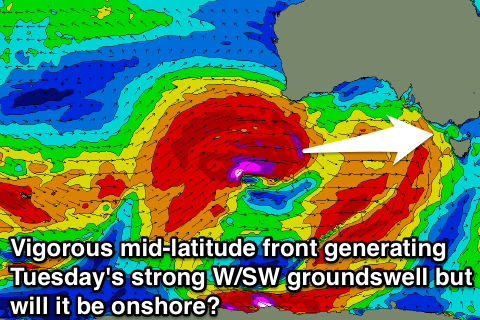
On dark we may see a much stronger increase in long-period W/SW groundswell, but Tuesday is when this swell is expected to peak.
The largest of the bunch, this swell will be produced by a secondary stronger mid-latitude front projecting a fetch of severe-gale to storm-force W'ly winds over the active sea state generated by the initial front, towards WA and then through the Bight again while weakening.
An XXL swell will be generated for WA Sunday, with the swell peaking across our coast in the moderate to large range Tuesday morning.
The westerly direction will result in a wide variation of wave heights, but we should see sets hitting the 6ft range on the Surf Coast (possibly larger at magnets) and 8-10ft+ on the Mornington Peninsula.
Conditions on Monday will be good with a N'ly tending NW breeze ahead of a mid-late afternoon W/SW change, but come Tuesday fresh S/SW winds will create poor conditions across most spots. There's a slim chance for an early W'ly around Torquay, but we'll review this Monday as it revolves around a developing cut-off low somewhere in the Tasmanian region.
Depending on where this low sits, we'll either see building levels of SW or S/SE swell through the middle of next week, and with the current divergence it's not worth laying down any numbers. So have a great weekend and check back here Monday for the latest update.
Comments
By exposed breaks do you mean Bells/Winki for tomorrow ?
Yeah they'd be in the mix.
Nice lines at 13th Beach.
there has been nice lines since tuesday:)what a great run of swell this winter so far!
The predicted Low off Wilsons prom, craig.... Next week..... Is that the sort of fetch that may send a bizarro ese swell into bass straight, with novelty once in a blue moon spots breaking?
Whole dynamics of this system have changed since Friday and no not any more.
Definitely no east in the wind east of Melbourne today.
Looks like it stayed fairly north? N/NNE around expectations?
Yeah I was just a bit further east than Phillip island, it was just bit too n/nw and blowing across the face instead of straight on. If it had that tiny bit of east in it it would of been pumping! Haha oh well can't win Em all..
Ah, spewing.