Good period for the Surf Coast, largest Friday afternoon

Victoria Forecast by Craig Brokensha (issued Wednesday 24th February)
Best Days: Early Thursday east of Melbourne, all morning to the west, Friday Surf Coast, Saturday morning Surf Coast, Sunday morning both coasts, Tuesday both coasts
Recap
Pumping waves across both coasts yesterday with a fun pulse of SW groundswell to 4-5ft on the Mornington Peninsula and 3-4ft at swell magnets (2-3ft elsewhere) on the Surf Coast with offshores most of the day until a late onshore change.
Today similar conditions are being seen across both coasts with a secondary similar pulse of swell and morning offshores. An onshore change has come in across the Mornington Peninsula much earlier than expected though, with cleaner conditions continuing to the west.
This week and weekend (Feb 25 - 28)
Today's swell should ease back from the 2ft+ range on the Surf Coast tomorrow and 3-4ft+ on the Mornington Peninsula, but early N/NW winds will swing W/NW ahead of a W/SW change, so aim for the early east of Melbourne, with more time available to the west.
Moving into Friday our good pulse of SW groundswell has now been upgraded a touch again after weakening a bit in Monday's notes.
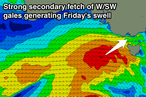
Firstly the frontal system that's currently firing up from the polar shelf towards us will only weaken temporarily this evening before a the secondary intensification projects a very healthy fetch of additional W/SW gales through our swell window tomorrow.
 This will produce a moderate to large sized SW groundswell for Friday, building from 3-4ft during the morning on the Surf Coast to 4-5ft into the afternoon, while the Mornington Peninsula should build from 6ft to a larger 8ft through the afternoon.
Conditions will be best on the Surf Coast with a fresh morning W/NW breeze, giving into a W/SW change late morning.
A small embedded low racing in on the back of the frontal activity Friday should produced a slightly smaller reinforcing W/SW groundswell for Saturday, with the Surf Coast due to continue in the 3-5ft range through the morning, easing later and then down from 3ft+ Sunday morning. The Mornington Peninsula is due to offer 6-8ft waves, easing back from 5-6ft Sunday morning.
Morning W/NW winds will again favour the Surf Coast Saturday morning, swinging onshore late morning, while Sunday is due to see more variable breezes, creating fun waves across both regions.
Next week onwards (Feb 29 onwards)
As touched on last update, a good pulse of long-period SW groundswell is due through Monday as a deep and intense polar low fires up over the weekend.
A fetch of severe-gale to storm-force W/SW winds are forecast to be generated, with a strong SW groundswell due to fill in Monday morning, reaching 4ft on the Surf Coast through the afternoon and 6ft+ on the Mornington Peninsula.
Winds are a little dicey though with a light to moderate S/SE'ly more than likely, cleaner Tuesday as the swell eases under NE breezes.
Longer term there's nothing major on the cards till later next week, so make the most of the coming run of waves!