Leave Saturday, better Sunday mid-late morning with a building swell

Victoria Forecast by Craig Brokensha (issued Friday 15th January)
Best Days: Sunday east of Melbourne, Monday and Tuesday both coasts, Wednesday morning east of Melbourne
Recap
Small onshore waves yesterday morning ahead of a building windswell through the afternoon, ahead of a stronger groundswell this morning peaking at 3-4ft on the Surf Coast and 6ft+ on the Mornington Peninsula but with fresh to strong S'ly winds.
This weekend and next week (Jan 12 - 17)
Today's good pulse of SW groundswell was generated by an intense mid-latitude low pushing in across us, with it quickly tracking south-east and under Tassie yesterday.
We'll see the swell ease as a result, down from 2-3ft on the Surf Coast and 3-5ft on the Mornington Peninsula tomorrow but with lingering E/SE winds. This will continue to create average conditions only for desperate surfers.
Sunday is the day to surf, but early small waves are expected ahead of a good kick in SW groundswell through the day.
Small 2ft to possibly 3ft sets are due around dawn on the Mornington Peninsula with a gradual increase through the day, reaching 4-5ft into the evening. The Surf Coast will be tiny early, building to 2ft to maybe 3ft on dark across swell magnets.
Morning NE-N/NE winds will create great conditions ahead of mid-late afternoon sea breezes.
The source of this groundswell is a broad and relatively strong polar frontal progression, but the embedded low that was due to generate stronger core winds isn't on the cards anymore, so we'll see a touch less size than forecast Wednesday.
A drop in size is due through Monday from 2ft+ across most breaks on the Surf Coast with 3ft sets at 13th Beach and other exposed breaks, with easing 3-5ft waves on the Mornington Peninsula. Great conditions are expected with local offshore winds ahead of a shallow onshore change mid-late afternoon.
Tuesday will be clean again with fresher local offshore winds persisting all day and small clean 2ft waves on the Surf Coast with 3-4ft sets on the Mornington Peninsula.
The outlook for the middle to end of next week has been a little all over the place this week, but we've now had an improvement in the polar frontal progression firing up south-west of WA.
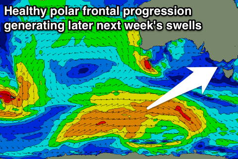 This storm should produce a healthy fetch of pre-frontal and post-frontal gales, swinging ideally through our south-western swell window, generating a moderate sized SW groundswell for Thursday and Friday.
At this stage we're looking at good 3-4ft sets on the Surf Coast and 6ft to occasionally 8ft waves on the Mornington Peninsula for Thursday, followed by a secondary similar pulse Friday.
Conditions are a little unknown as a weakening mid-latitude low pushing in from the west brings with it an onshore change at some stage Thursday. With this uncertainty, we'll have a closer look on Monday. Have a great weekend!
Comments
Hey Craig ,
What is going on with the surf forcast for Tuesday and Wednesday yesterday morning was looking offshore all day Tuesday and most of Wednesday and now it's got SW winds Tuesday and ESE Wednesday why has the wind just completely changed. Tuesday is 36 degrees and it's saying southerly winds surly that's wrong
Looks like that new swell is filling in nicely. Was tiny this morning!
Interesting local obs too - the South Channel Island AWS isn't picking up the sea breeze that's evident on our Portsea surfcam either.
It is rather interesting when that happens thermalben, with the south channel being inside the bay it picks up the northerly but not the sea breeze from bass straight, Walking out on the reef at the heads you have a warm northerly blowing on one side then the other a cold southerly. Interesting what that occurs. At least I isn't blowing easterly and there is some swell about.
Nice corduroy at Portsea this morning.
Decent options on the outer bank, and some tidy inside reforms too!