Large prolonged swell event from Saturday afternoon

Victoria Forecast by Craig Brokensha (issued Wednesday 29th July)
Best Days: Surf Coast every day over the coming period, Mornington Peninsula early Thursday, Sunday and then protected spots from Monday
Recap
Solid sets still to 3-5ft across the Torquay regions yesterday morning with offshore tending W'ly winds. The Mornington Peninsula was still too large and bumpy with better options at Flinders, and tiny peelers inside Western Port.
Today the surf was back to a smaller and clean again 2-3ft on the Surf Coast and cleaner 4-5ft sets on the Mornington Peninsula. A late and good pulse of new SW groundswell is due across both coasts this afternoon, with 3-4ft sets likely by dark on the Surf Coast and 6ft+ sets on the Mornington Peninsula. This swell will peak early tomorrow, discussed in more detail below.
This week and next week (Jul 28 – Aug 7)
This afternoon's late kick in SW groundswell should offer good size waves across both coasts early tomorrow, before easing into the afternoon and steadying Friday as a weak front pushing in from west produces a steadying W/SW swell.
The Surf Coast should see 3-5ft sets early, easing back through the day and then holding around 3ft Friday. The Mornington Peninsula should ease from 6-8ft with 5-6ft sets persisting Friday.
Winds are due to be fresh to strong from the N/NW tomorrow, swinging more NW later in the day, while the Mornington Peninsula may see an early N'ly breeze.
Friday should then see winds hovering between the W/NW-NW all day.
Our dynamic and large run of swell from this weekend is more than on track.
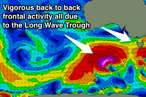 A strengthening node of the Long Wave Trough will move in slowly from the west over the coming days, taking almost a week to traverse across the south-east of the country.
What this will in turn do is aim front after front after front up through our swell window, generating a prolonged run of large swell from Saturday through Thursday next week.
Looking at the specifics, the first system to fall under the LWT's influence will develop south-west of WA today and project a fetch of SW gales towards us over the coming days before pushing across Tassie Saturday.
A pre-frontal fetch of W/NW gales ahead of this front will generate an initial pulse of SW groundswell for Saturday morning, with the larger stuff filling in through the afternoon.
The Surf Coast should build from 3ft+ to the 5-6ft range later in the day, with the Mornington Peninsula increasing from 6ft+ to 8ft+ later in the day.
The swell should hold a similar size Sunday morning and then ease through the day as we fall in between pulses.
A much stronger follow up polar frontal system pushing in on a similar track to the initial front, and over an already active sea state, will produce a fetch of severe-gale W/SW winds through our swell window Saturday.
A large, long-period SW groundswell will result, with it possibly showing late in the day Sunday, but a peak is due Monday with 8ft waves across the Surf Coast and 10ft bombs at swell magnets, with larger 12ft+ surf on the Mornington Peninsula.
This groundswell should ease through the day, but a less favourably aligned W/SW groundswell will fill in later in the day, generated by another front piggy-backing over the initial system, but heading up and into South Australia.
This swell should peak early Tuesday morning with the Surf Coast easing from 6ft to sometimes 8ft at exposed breaks, and 10ft+ on the Mornington Peninsula.
One final pulse of large S/SW groundswell is due later Wednesday afternoon/Thursday morning, from a final polar front firing up in our southern swell window early next week.
The size off this system only looks to be in the 4-6ft range on the Surf Coast and 8ft on the Mornington Peninsula, but we'll have to review this all again Friday.
Now, what are the conditions looking like?
Saturday and Sunday look great with a fresh to strong but easing W/NW winds Saturday, and N/NW tending NW winds Sunday, more than likely N'ly early in the day, which is unfavourable for selected breaks.
Monday should see early and fresh to strong W/NW winds, but a W/SW change will move through mid-late morning.
Tuesday should then see W/NW winds, possibly tending W/SW through the afternoon and then possibly onshore SW winds Wednesday (W/NW likely early). We'll go over all this again Friday though with more confidence.
Comments
I'm already feeling a bit anxious in anticipation for Monday, Tuesday.
Yew!
Downgraded on the surfcoast from Monday's forecast 6-8ft to today's 5-6ft for Sunday?
Ahh spewing
Yeah, was a ball park figure on Monday, weekend's swell downgraded a touch but early next week's, upgraded.
You'll be happy Goofy, latest update now has the swell pulsing larger late Sunday now. It'll keep moving around until the models firm on each fronts pace and track,
Haha all good Craig, I'm heading over anyway so whatever it is I'll be happy. Going to have a cup of tea with Vic Local afterwards..
You coming down?
Not this one, should be though! Gotta watch the Crows smash the Swannies Saturday arvo/evening!
Ohh yeah, they should too I reckon. Should be a good game
The swell due late today is showing nicely on the Cape Sorell buoy and Point Nepean picking up 18-20s peak periods.
Solid sets now showing at 13th Beach and on the bommies..
Point Nepean..