Fun period ahead with good swells and favourable winds

Victoria Forecast by Craig Brokensha (issued Friday 15th May)
Best Days: Saturday, Sunday morning, Monday, Tuesday, Wednesday morning
Recap
Generally poor conditions with a large easing SW swell yesterday which was workable around Torquay for a period early, and then this morning the swell was smaller but with no early W'ly offshore and more so fresh S/SW winds across all locations.
 This weekend (May 16 - 22)
The surf should continue to drop into tomorrow morning across both coasts with 2-3ft waves on the Surf Coast and 4-5ft sets on the Mornington Peninsula.
A good new SW groundswell is due to arrive during tomorrow afternoon, generated by a strong polar frontal system over the past couple of days.
This swell should pulse to a stronger 3ft+ across the Surf Coast and 5-6ft on the Mornington Peninsula before easing from 3ft on the sets and 4-6ft on the Mornington Peninsula Sunday morning.
Winds tomorrow are still looking dicey but a little better than they were on Wednesday, with a more variable breeze due across both coasts through the morning, which should persist into the afternoon, creating fun conditions for those who aren't fussy.
Come Sunday both coasts should be clean with local offshore winds that will then swing more W'ly into the afternoon. So get out through the morning.
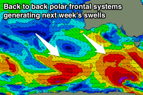
The outlook for next week is great with pulse after pulse of SW and S/SW groundswell along with generally favourable winds.
This will be due to the westerly storm track being restricted to the poles while maintaining steam, with a series of back to back and vigorous polar lows due to fire up in our swell window.
An initial first and strong system over the weekend should produce a primary S/SW pulse that should be seen Tuesday morning to 3ft to occasionally 4ft across swell magnets on the Surf Coast and 5-6ft+ on the Mornington Peninsula.
A secondary broader but less consolidated system is then forecast to develop through Sunday and Monday, producing a secondary pulse that may be seen later Wednesday but should peak Thursday morning to a similar size.
The best pulse of swell is due to fill in Friday through, produced by a better aligned and strong fetch of severe-gale to storm-force W'ly winds along the polar shelf Tuesday,
This swell should build through the morning and peak around midday/early afternoon to 4-5ft on the Surf Coast and 6-8ft on the Mornington Peninsula.
Further pulses are then due through the weekend and the following week but we'll look at this closer on Monday.
Back to the conditions next week, and Monday looks great with local offshore morning winds that'll tend variable into the afternoon, with fresher N'ly winds through Tuesday (tending locally offshore).
Wednesday should see morning N'ly winds ahead of a shift to the W/NW through the afternoon ahead of a late afternoon S/SE change.
Thursday looks poor with lingering fresh SE winds that may even continue into Friday but the models diverge on a possible low forming east of us later next week. Therefore we'll have another look at this on Monday. Have a great weekend!
Comments
Hey Craig,
What a sick weekend of waves last weekend! Yeew it was so pumping, I got some amazing huge waves! Question, I saw on the Bells Beach Surf Sanctuary facebook page that all the sand had been washed away from bells beach down to winkis. Does this mean that the bank at bells will be no good but good at winkis. Is it similar to snapper rocks? When the WSL was there I read somewhere that when the sand goes from snapper, Kirra gets really good. Does this mean that winki will get super hollow with the sand there now? I'm hoping that it could be good for trying to get barrels again!
Ralf