Great Tuesday, good swell for the weekend again

Victoria Forecast by Craig Brokensha (issued Monday 19th January)
Best Days: Tuesday east of Melbourne, Wednesday morning on the Mornington Peninsula, Thursday morning both coasts, Saturday morning Surf Coast, Sunday morning Surf Coast
Recap
Saturday saw the Surf Coast light up as a strong and powerful new W/SW groundswell filled in under W/NW offshores, that persisted right through until the mid-afternoon. Size wise most breaks built to 4-5ft, with 6ft bombs occasionally rolling through at swell magnets.
A secondary reinforcing SW swell filled in Sunday morning keeping similar sized sets hitting the Surf Coast, but winds were only favourable from early to mid-morning before gusty SW change pushed through.
Today, onshore S/SE winds were lingering in the wake of yesterday's change with a drop in swell leaving no decent options for a surf.
This week and weekend (Jan 20 - 25)
As pointed out last week, tomorrow will be best for locations east of Melbourne as the weekend's swell continues to ease and becomes much more manageable on the beaches. The Mornington Peninsula should ease from 3-5ft under fresh and gusty N/NE winds that should hold from the N'th into the afternoon, and tend N/NW on the Surf Coast. The Surf Coast will be much smaller though and easing from 2ft at most locations, with sets near 3ft early at exposed breaks.
Wednesday should be clean across both coasts early with a variable tending light offshore breeze but the Mornington Peninsula will offer the only decent wave with a small 2ft swell.
We were expecting a short-lived pulse of W/SW groundswell Thursday from a strong but small mid-latitude low tracking from WA down towards Tassie, but this system isn't expected to form anymore, with only a small and very inconsistent uptick in SW swell due. This is being generated today by a small and weak polar low, with only sets to an infrequent 2ft due Thursday morning on the Surf Coast with 3-4ft+ waves on the Mornington Peninsula before easing into the afternoon.
 Winds are expected to be favourable across both coasts again and locally offshore ahead of afternoon sea breezes.
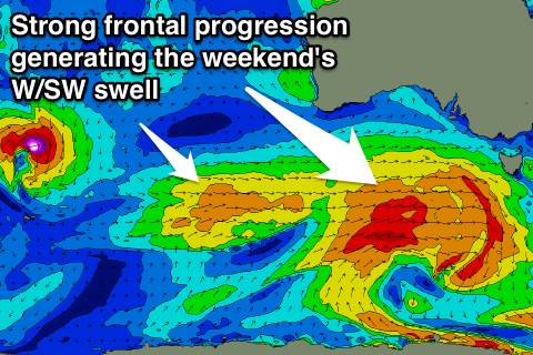
From Friday we're expected to see some healthy W/SW groundswell impacting the state again, with a series of good pulses due from the afternoon through until early the following week.
This will be linked to another strong node (peak) of the Long Wave Trough moving in from the west during the second half of this week before stalling while weakening across our region.
A series of strong cold fronts should be directed through our western swell window during the second half of the week, with the largest swell due Saturday afternoon at this stage, coming in at 3-5ft on the Surf Coast and 6-8ft on the Mornington Peninsula. Winds generally look to be from the NW to SW at this stage, but we'll review this again on Wednesday.
Comments
Hey craig what days do you think weaterport will be good
*westernport