Average days ahead, improving from Tuesday next week

Victoria Forecast by Craig Brokensha (issued Wednesday 22nd October)
Best Days: Friday mid-late morning across locations east of Melbourne, Sunday morning for keen surfers in protected spots east of Melbourne, Tuesday onwards on the Surf Coast
Recap
The Mornington Peninsula and Phillip Island offered the best waves yesterday with a fresh and gusty E/NE wind and easing 3-5ft of swell across exposed breaks. The Surf Coast was average, with 13th Beach providing the best conditions with a mix of SE windswell and SW groundswell.
Today both swells have backed off and become tiny across the Surf Coast while the Mornington Peninsula is the pick again with a clean easing 2-3ft of swell. Winds should tend variable after lunch ahead of an onshore change mid-afternoon.
This week (Oct 23 - 24)
Tomorrow will be a write-off with poor onshore S/SW tending SE winds expected across both coasts in the wake of this afternoon's change. The swell will be tiny as well most of the day ahead of a late kick in new SW groundswell along with some localised windswell.
Friday is now looking a little more dynamic than it was on Monday with the SW groundswell still expected to ease from 2ft to occasionally 3ft on the Surf Coast and 4-5ft+ on the Mornington Peninsula. But also in the mix will be a junky and much more noticeable SE windswell, generated by a strong to gale-force fetch of E/SE winds through Bass Strait tomorrow evening and Friday morning.
This should come in at a 2-3ft across the Surf Coast and smaller on the Mornington Peninsula.
Now, conditions will be average at dawn with a fresh E'ly breeze, but this is expected to ease through the morning and tend N'ly before becoming variable and then giving way to onshore winds late afternoon. Therefore the mid-late morning is expected to offer improving conditions and the best waves.
This weekend onwards (Oct 25 onwards)
Saturday is unfortunately looking average now with onshore S/SW tending S/SE winds and small amounts of fading swell as a surface trough moves in from the west quicker than ideal.
Sunday will only be slightly better as winds swinging back to a fresh E/NE'ly and a new long-range SW groundswell comes in at 3-4ft across the Mornington Peninsula. The Surf Coast will be poor and a small weak junky SE windswell is also expected to be in the water.
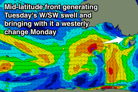 A complete swing in wind direction will be seen through Monday as another surface trough moves in from the west, but this one will be linked to a stronger cold front pushing through the Bight, aiming a fetch of gale to severe-gale W/SW winds towards us.
This should generate a medium sized W/SW groundswell for Tuesday but there'll also be a lot of windswell in the mix as it brings with it fresh and gusty W/SW change Monday afternoon.
Size wise we should see 3ft waves across the Surf Coast Tuesday with 6ft surf on the Mornington Peninsula under fresh W/NW tending W/SW winds.
For the rest of the week we're looking at plenty of fun W/SW tending SW groundswell now as a series of follow up polar fronts generate healthy fetches of W/SW gales under the country and to our south-west next week.
Each pulse at this stage looks to be around the 3ft+ range on the Surf Coast and 6ft+ on the Mornington Peninsula under W/NW to W/SW winds, but we'll review this all again on Friday.