Good waves to end the week; poor weekend; great Monday

Victoria Forecast by Craig Brokensha (issued Wednesday 11th Jun)
Best Days: Thursday, Friday, Monday through Wednesday on the Surf Coast
Recap
A small to tiny westerly swell eased across the coast yesterday under N'ly winds, favouring exposed locations east of Melbourne
Today a new W/SW groundswell has arrived but the Surf Coast is missing most of the size, while the Mornington Peninsula is coming in at a clean 3-4ft with fresh N'ly winds. Winds should persist from the N'th all day as the swell kicks a touch more into the afternoon.
This week (Jun 11 - 13)
The medium sized pulses of W/SW groundswell due through tomorrow and Friday are still on track, with tomorrow's expected to be the least consistent and smallest, coming in at 2-3ft on the Surf Coast and 5-6ft on the Mornington Peninsula.
A better and more consistent pulse is due through Friday afternoon, reaching 3-4ft on the Surf Coast (possibly the odd bigger set at 13th Beach) while the Mornington Peninsula should see 6ft+ sets.
Winds tomorrow will be favourable for both coasts during the morning and locally offshore, but a slight shift to the N/NE through the afternoon will favour 13th Beach, Fairhaven and the Mornington Peninsula over the Surf Coast reefs.
Friday should see winds hold from the N'th through the morning and likely tend light N/NW or variable into the afternoon.
This weekend onwards (Jun 14 onwards)
The swell due over the weekend, more so Sunday has been upgraded since Monday with the polar frontal progression generating the swell coming in a touch stronger and more favourably aligned.
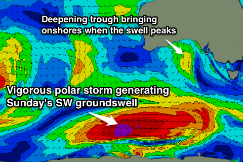 The only problem is that winds will swing onshore around dawn Saturday and persist through Sunday as a deepening surface trough moves in from the west.
This will bring strong S'ly tending S/SW winds on Saturday that will persist into Sunday with slightly less strength before swinging SW through the afternoon.
Size wise, the swell should peak in the 3-5ft range across the Surf Coast Sunday with 6-8ft sets on the Mornington Peninsula, with a drop due through Monday from 3-4ft and 6ft+ respectively.
On the upside, Monday is looking great on the Surf Coast as winds swing back to the W/NW.
Into the middle of next week the swell will continue to drop away as winds persist from the NW, favouring the Surf Coast.
Longer term the models are wildly divergent on the possibility of an intense mid-latitude low pushing in from the west, generating a new W/SW groundswell for late next week. With this divergence it's too hard to comment on what to expect, but hopefully we'll have a clearer idea on Friday.