Dire Straits
Wednesday, 19 January 2022
Dire Straits
Wednesday, 19 January 2022
It's not a healthy looking forecast with limited swell energy though with favourable winds for the exposed beaches.
It's not a healthy looking forecast with limited swell energy though with favourable winds for the exposed beaches.
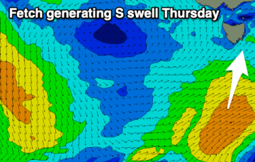
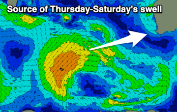
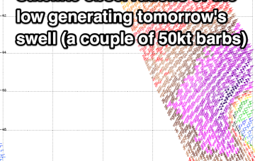
A storm coming off the southern flank of the Gyre early this week intensifies to storm force as it approaches the dateline generating a large area of 30ft seas into the middle of the week.
A new mix of swells are due from tomorrow but with initially average winds, improving on the backside.
Some fun swell with favourable conditions are due from later week.
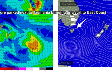
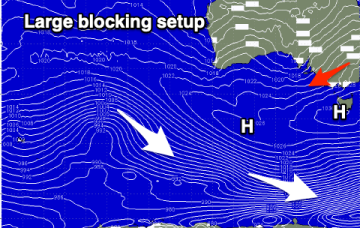
With high pressure parking itself beside Tasmania for most of this week we’re expecting a period of tiny surf to become established through Thurs into the weekend and early next week, with swell sources effectively blocked by the large high .
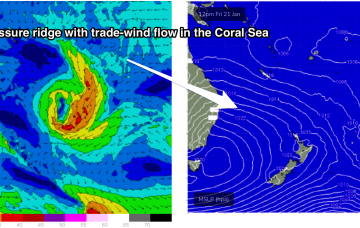
By Fri an extensive coverage of 20-25knot SE winds through the lower Coral Sea should rebuild wave heights into the 1-2ft range across the region, with surf holding into the weekend before slowly easing next week as the trade flow weakens.
Ex TC Cody slipped behind the North Island late this weekend and is now slowly drying up as a swell source. Due to the slow moving nature of the system as it approached the North Island there’s still some more solid surf to come, with a final pulse of E/SE swell expected Wed.
Our good, new W/SW-SW groundswell due today has hit the offshore wave buoys and is on the build.
A trough brings a S’ly change tomorrow , with another strong high tracking south of the Bight poised to be the main weather feature this week.
A good quality swell for tomorrow with average though workable winds, cleaning up on the beaches later week but with no swell.