Good swell on the build

South Australian Surf Forecast by Craig Brokensha (issued Monday January 17th)
Best Days: Later today on the Mid Coast, Mid Coast tomorrow and Wednesday morning, keen surfers South Coast Thursday morning, beginners on the Mid Saturday afternoon and Sunday
Features of the Forecast (tl;dr)
- Mod-large W/SW-SW groundswell arriving later today, peaking tomorrow AM with fresh SE-S/SE winds
- Easing mid-period SW swell Wed with a S/SE windswell in the mix with strong SE tending S/SE winds
- Easing mix of small, weak swells Thu with E/NE tending fresh S/SE winds
- Fading surf Fri with NE tending S/SE winds
- Tiny, inconsistent W/SW swell Sat PM and Sun with morning E/NE winds
Recap
Bumpy, tiny surf across the South Coast on Saturday, cleaner Sunday morning but still only tiny and for the desperate. The Mid Coast was clean but tiny Saturday with a little spike in swell yesterday, back to 1ft today.
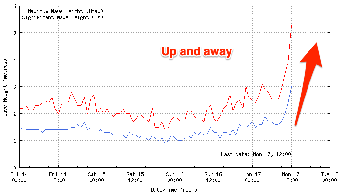
Later today our new W/SW groundswell will start to show, and Cape du Couedic has displayed a strong J-curve, signalling the arrival of a strong swell front. There should be some good waves for the late with winds shifting S/SE on the Mid Coast and easy 2ft sets.
This week and weekend (Jan 18 - 23)
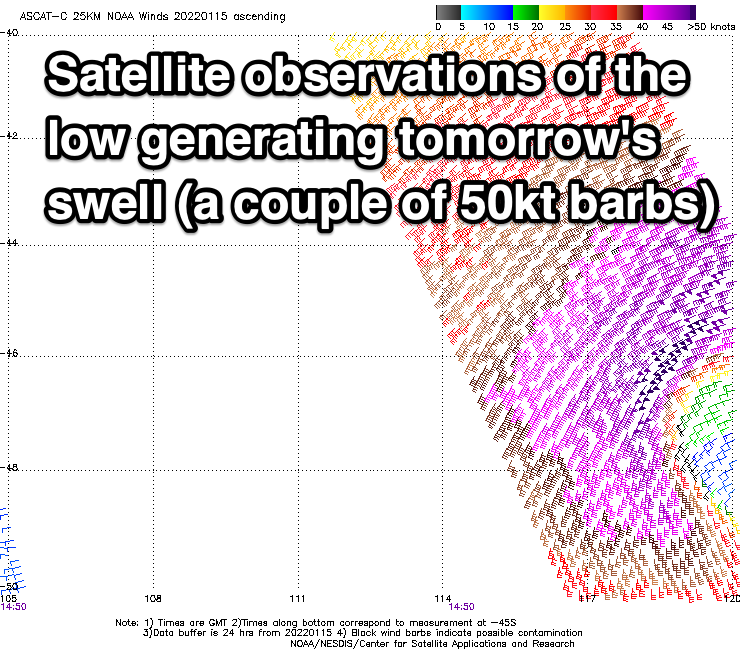
Later today's strong pulse of W/SW groundswell is due to peak tomorrow morning across both coasts, generated by a strong mid-latitude low that fired up south-west of Western Australia Friday evening.
A great fetch of gale to severe-gale W/SW winds were projected through our western swell window, then through our south-western swell window as it slowly weakened, with the low now breaking down to the south-west of Tasmania.
Size wise the Mid Coast should come in at 2-3ft on the favourable parts of the tide.
The South Coast should offer 4-6ft surf but with a moderate to fresh SE-S/SE breeze, the Mid will be the go with bumpy, average conditions across Victor.
 The swell will ease back on the Mid Coast from 1-2ft on Wednesday with easing 3ft+ waves down South. Winds will be gusty from the SE creating poor conditions down South while adding some additional S/SE windswell to the mix, clean all day on the Mid Coast.
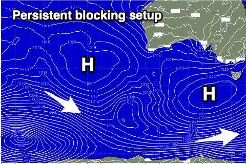
Winds will improve into the end of the week for the South Coast, but the broad, slow moving high linked to the run of SE winds will block our main swell windows. Therefore conditions will become cleaner but there'll hardly be any swell to make the most of.
A peaky 2ft+ wave is due Thursday morning under E/NE winds ahead of sea breezes down South, cleaner Friday but tiny.
Unfortunately there's no new swell due into the weekend but winds will be favourable and E/NE again through the mornings. The Mid Coast will likely see tiny 1ft waves for beginners into Saturday afternoon and Sunday, generated by a weak, distant mid-latitude frontal progression that's currently just north of the Heard Island region.
Longer term there's nothing major due for the South Coast while tiny pulses of distant swell look to continue on the Mid. More on this Wednesday.
Comments
Good ratios here..
Mid looked better than Surf Coast this morning. Size came in under. Only a very occasional 4ft set at the magnets.
Yeah even with CS looking solid!
Yeah it looked like it was going to be on as CS rocketed up last night!
Perfect for the windsurfers this arvo.