Good swell spoilt by south winds

Victorian Surf Forecast by Craig Brokensha (issued Monday 17th January)
Best Days: Tomorrow morning for the keen and experienced, desperate surfers on the beaches Thursday morning
Features of the Forecast (tl;dr)
- Mod-large W/SW groundswell peaking tomorrow AM with moderate S tending fresh S/SE winds
- Easing W/SW groundswell Wed with a building SE windswell under strengthening E/SE-SE tending SE winds
- SE windswell Thu with easing mid-period SW swell with fresh E tending S/SE winds
- Fading SE windswell Fri with E/NE tending S/SE winds
- Tiny surf on the weekend with morning E/NE winds and S/SE sea breezes
Recap
Clean conditions across the Surf Coast each morning on the weekend but with a tiny mix of swells, onshore today as tiny, average surf continues.
This week and weekend (Jan 18 – 23)
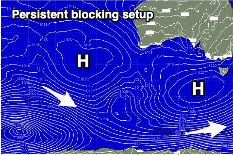
Looking at the week ahead and we've got a strong swell due tomorrow but winds will mostly spoil it, before we see an entrenched pattern of winds from the eastern quadrant along with localised south-east windswell.
 There is a window of OK conditions tomorrow morning though with a weaker, moderate S'ly breeze due, freshening from the S/SE through the day.
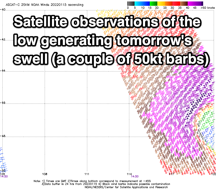
Swell wise, a moderate-large W/SW groundswell should peak through the morning, generated by a strong mid-latitude low that developed south-west of Western Australia Friday evening.
A great fetch of gale to severe-gale W/SW winds were projected east through our western swell window on the weekend, producing a consistent, good sized W/SW groundswell that should peak to 4-5ft+ on the Surf Coast and 8ft on the sets to the east.
The swell will start easing into the afternoon (but only slowly owing to the low stalling sotuh-west of us today), dropping more noticeably Wednesday as winds shift E/SE-SE and strengthen. This will kick up a building SE windswell through the afternoon on the Surf Coast.
This run of winds from the east to south-east will be linked to a progression of strong highs moving in from the west, under the country as inland surface troughs squeeze their northern flanks.
This will block our main swell windows resulting in no decent swell as wind start to improve for the beaches on Thursday.
Winds look to shift E'ly Thursday morning but with only a small mix of weak, easing mid-period SW swell and SE windswell to 2ft+ on the Mornington Peninsula, 2-3ft on the Surf Coast.
 Friday looks cleanest with an E/NE offshore but the SE windswell will be tiny and fading across both regions.
Unfortunately into the weekend there's still nothing significant on the cards with tiny levels of S/SW swell spreading up from late developing polar frontal activity unlikely to top 1-2ft on either coast. Winds will remain favourable and E/NE through the mornings ahead of afternoon sea breezes.
Longer term there's still nothing significant on the cards for most of next week, so maybe try and make the most of tomorrow's bumpy, workable waves.
Comments
Any chance we will start to see some of that Tuesday swell arrive this afternoon (Monday) ?
Not the swell proper, but some weaker, mid-period energy on dark.
Thanks - better than nothing I guess. It’s been pretty grim while our Northern cousins feast
Hi Lost, it's not as glossy as you have seen and read up this way. Super crowded on the points, bays etc with only a few options handling the swell and sweep. We have also had unfavorable northerlies to throw in the mix. The crowds thin a little when the ocean settles and opens up the beach breaks with morning off shores but that pattern is still a few months away. Best to remain patient and wait for the classic Vic late summer/ Autumn conditions with good weather and milder ocean currents.
That still sounds better then what we have had for 2-3 months straight, flat ocean with lots of southerlys and easterlys. Surely some novelty waves have been turning on up north with the massive swells and northerly winds. I'd surf a tsunami right about now just to get in the water and you guys even got one!
Grass is greener and all that - I hear you. Hope you are finding some amping at the crowds.
There have been some fun sneaky surfs with no one out on the west end of the peninsula, the best summer I've seen for a few years.
Craigos, whats the deal wheres this swell?
Not sure, Sorell was strong.
It’s barely 2ft
Too west it seems.
Also have heard and seen reports of 3-4ft sets on the magnets. Slow but.
Really is raining shit on Vicco surfers right now... finally get a forecast of solid swell, CS was strong...annnd then nothing.
Strong 6fters in the AM on MP.