Dual swells to provide the goods this week

Sydney Hunter Illawarra Surf Forecast by Ben Matson (issued Mon Mar 11th)
Features of the Forecast (tl;dr)
- Strong E/NE trade swell building Tues, peaking Wed, easing Thurs, with generally light winds and sea breeze
- Small south swell building Wed PM, showing best Thurs
- Fri a write off with poor winds
- Nice south swell building Sat (may be wind affected tho), showing best Sun with favourable light winds
- Plenty of swell sources for next week, most inyteresting is a long period SE groundswell Thurs/Fri
Recap
Fun southerly swell built Saturday and then eased into Sunday, sets topped out the 2ft+ mark at exposed south swell magnets though most other locations were much smaller. A new E/NE swell started to show yesterday afternoon though we've seen a more definitive size increase today with occasional 3ft+ sets of trade swell being accompanied by light winds.
This week (Mar 12 - 15)
Lots of swell to look forward to this week, and winds should remain light under a weak local synoptic pattern.
A broad, established trade flow is currently producing very large surf in Northern NSW (~8ft+ or so), and we're in a good position to see a healthy percentage of this filter into southern NSW.
Wave heights should build slowly from Tuesday morning, reaching a broad plateau in size from the afternoon, through Wednesday and maybe even early Thursday, then trending down into Thursday afternoon.
At its height, sets should manage 3-5ft at beaches with good exposure to the north-east. And conditions will be nice and clean with light winds and sea breezes each day.
South facing beaches won't pick up as much size, however they will see some new energy showing Wednesday afternoon from a south swell, generated by a strong front tracking below Tasmania tomorrow morning. Early morning won't see much size but the afternoon should push 2-3ft and a few bigger sets are likely early Thursday before wave heights ease through the day.
This swell combo should produce nice beaches at those locations open to both directions.
Make the most of the next three days, as a gusty S/SE change is expected Friday, at which point we'll be in-between swells - the previous trade swell will have eased back to 2-3ft and the south swell will be all but gone, though a new south swell will be pushing up into the coast late in the day, from a new frontal passage below Tasmania on Thursday.
This weekend (Mar 16 - 17)
I really like the look of this next south swell actually, the associated front isn't terribly strong so periods/size won't be notable, but the fetch has a really nice angle up through our south swell window.
As such we should see good 3-5ft sets at south facing beaches on Saturday, with smaller options elsewhere owing to the swell direction.
However, lingering S/SE winds on the underside of a building ridge into Northern NSW means surface conditions may be bumpy, mainly north from Wollongong (we won't see much wind on the South Coast, expect good conditions here). The afternoon should see an improvement as wind speeds throttle back.
Light variable winds are expected across all coasts on Sunday, as overlapping south swells from a second front in the same sequence - plus some longer period S/SE energy from a stationary polar low well south of New Zealand on Wed/Thurs this week - provides a combination of flukey sideband sets and occasional long period bombs building from 3-4ft to 4-5ft into the afternoon - though with a less broader coverage in size across the region. Sunday is therefore the pick of the weekend at this stage.
Let's firm up the specifics on Wednesday.
Next week (Mar 18 onwards)
There's a lot to look forward to next week, with several interesting swell sources on the boil.
First up - strong though poorly aligned fronts through the Southern Ocean and lower Tasman will supply small background south swells throughout the first half of the week, maybe longer.
The tropics look active too with a re-established trade flow expected to be squeezed nicely by a series of tropical lows (one of which may develop into a tropical cyclone). So, there is some ENE swell potential for the back half of the week and the following weekend, though nothing is firm yet.
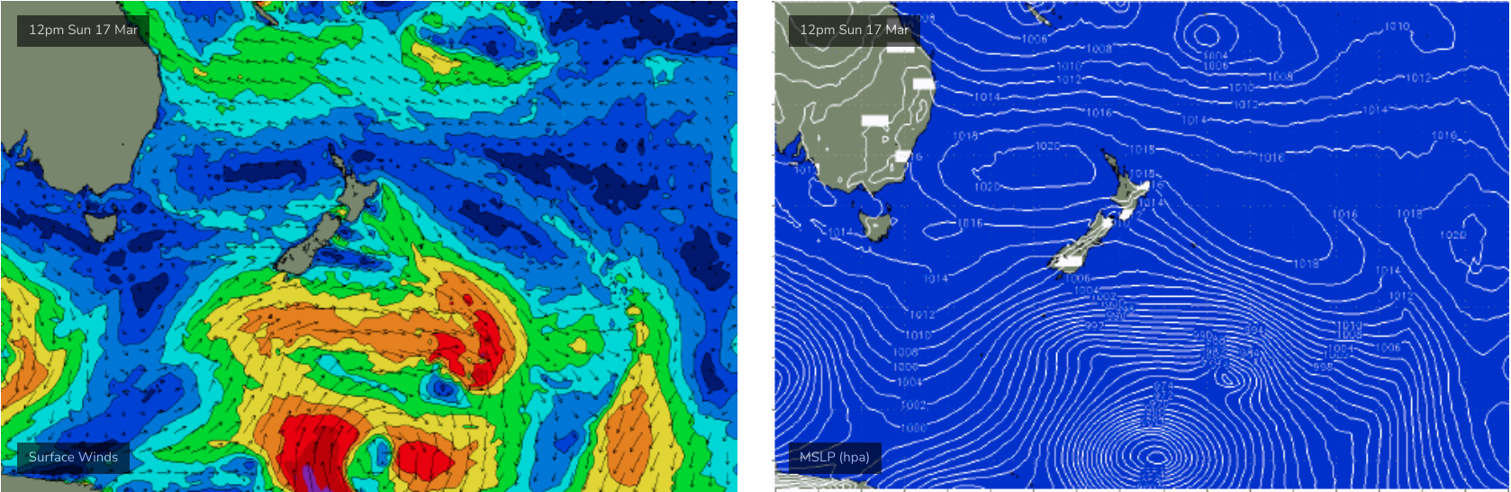
Probably the most interesting swell sources is a deep, slow moving polar low well to the SE of New Zealand this Sunday (see below) that looks like supply some rare long period SE groundswell to our region around Thursday and Friday. These swells often over-perform so I'm quietly confident that this could deliver some nice waves (local winds pending, of course).
More on that in Wednesday's update.
Comments
NE swell direction has been welcomed at my local today !!! ..not the 100-200m close outs from the south
Hey Ben whats going on with the QLD report im booked to go in the morning
Here ya go.
https://www.swellnet.com/reports/forecaster-notes/south-east-queensland-...
Thanks Ben feel better now
Looking forward to Wednesday's update