Complex outlook with lots of opportunity to capitalise on

Sydney Hunter Illawarra Surf Forecast by Ben Matson (issued Wed Feb 7th)
Features of the Forecast (tl;dr)
- Poor winds Thurs affecting a broad mix of interesting swells
- Better winds Friday with a good mix of S'ly swells
- Strengthening southerlies will deteriorate conditions on Saturday
- Improving conditions Sunday with plenty of swell, including new long period S'ly energy, potentially large at select bombies etc
- Nice waves all round Monday with light winds and an easing mix of still-strong south swells
- Fun trade swells holding all week, stronger through the second half and into next weekend
- NE windswell Tues, could be a decent window early Wed with a SW tending S'ly change
Recap
Tuesday offered a fun window of peaky NE (3ft) and S’ly (4ft) swells, with early light winds creating clean conditions before gusty southerlies kicked in mid morning, and wrecked the surf throughout the afternoon. The southerly swell has continued into today with 4-5ft sets at south facing beaches though gusty S’ly winds (briefly SW on the Northern Beaches) have maintain below average conditions. Wave heights are now slowly easing.
This week (Feb 8-9)
As Steve mentioned on Monday, the synoptic are quite complex at the moment.
Building trade swells are the smallest piece of the puzzle, showing nicely in the north of the state but unlikely to deliver much more than a couple of feet of low energy surf across Southern NSW.
Today’s southerly swells will continue to ease into Thursday, but we’ll concurrently see a building mid-range S/SE tending SE swell throughout the day, probably peaking on Friday morning. It’s not especially strong, but it is well aimed and positioned not too far off the coast, so we should pick up peaky 4ft sets at the height of the energy (except slightly smaller surf early Thursday).
The main issue with Thursday will be local winds, which are expected to hold steady out of the S/SE. A brief period of SW winds may be seen across one or two locations (i.e. Northern Beaches) but in general expect wobbly, bumpy conditions around most spots.
Similar surf will prevail on Friday, with two additional bonus items: (1) a better chance for lighter morning SW winds to encompass a bigger percentage of the Southern NSW coastline - the Hunter coast being the only region I’m not feeling favourable about, and (2) a secondary long period S/SE swell generated by gales off the ice shelf on Monday. It probably won’t provide any more size than the pre-existing SE swell, but should add occasional rogue sets into the mix as the swell trains combine.
Winds will likely clock around to the south through the day but should remain below 10-12kts, so surface conditions should remain manageable for the most part.
This weekend (Feb 10-11)
A strong Southern Ocean low/front pushing into the Tasman Sea on Friday will push gusty southerlies along the NSW coast on Saturday, which will then become anchored into the region by a strong ridge across SE Qld / Nthn NSW (also assisted by a tropical low, possibly a cyclone forming near New Caledonia).
This will maintain blustery S/SE conditions on top of a mix of swells from the same quadrant - local sources providing short/mid period energy, plus some new long range southerly swell generated by the Southern Ocean low (as well as abating energy from the aforementioned gales off the ice shelf).
Complex, innit?
Long story short, size should hold somewhere in the 3-4ft range at south facing beaches (smaller elsewhere) on Saturday but it’s not worth getting excited about due to the local winds.
However!
Sunday is a different story. We’ll see a similar mix of short/mid period energy from the same sources, but also a long period pulse of southerly swell from the Southern Ocean low, when it was travelling underneath SA and Vic, right on the western periphery of NSW’s acute south swell window (see below).
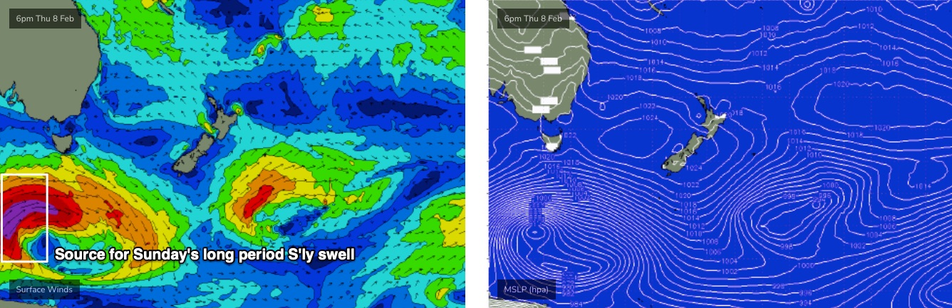
Peak swell periods from this region should nudge 17-18 seconds, reaching the South Coast late Saturday and remaining coasts into Sunday morning.
This means reliable fourth swell magnets and offshore bombies that focus these kinds of long period events could pick up significantly higher wave heights, over and above the local noise. They’ll total a small percentage of locations, but these spots could see 6-8ft+ sets. I'll take a closer look in Friday's update.
Local winds are expected to ease right back into Sunday though the absence of a synoptic offshore means we may still see some residual lumpiness through the lineup. Surf prospects (re: conditions) will improve with increasing southerly latitude, if that sways your decision-making any more.
Next week (Feb12 onwards)
The main features for next week look to be:
- Strong though easing southerly swells on Monday as the period slowly drops and the direction starts to veer S/SE (light winds, clean conditions). Well worth some flexi-time.
- Local NE windswell building Tuesday, possibly chunky for the late session, with a SW tending S’ly change overnight that might provide a window of good surf early Wednesday.
- An impressively long-lived trade swell from an anchored trade flow through the Northern Tasman Sea, probably maintaining 2-3ft sets for the first half of next week but possibly nudging a little higher through the second half of the week and the weekend, perhaps even lasting for a few days into the start of the following week too! Yep, a very long lived event is on the cards, but of course these trade swells do tend to favour the northern half of the state.
Anyway, there's stacks of surf to look forward too, we just gotta work around the winds.
See you Friday!
Comments
Low key excitement for the next week…
My local really needs the swell to be north of 140 degrees to get in.
This morning was GOOD! Maybe a few too many closeouts but had a fun sesh at DY. Winds were better than I expected, and crowd factor was only moderate. Great way to start the day.
All at Manly :p
A bit more energy in the water than I expected. Hopefully the winds are good again tomorrow.
That S/SE groundswell over-performing.
They always seem to do well in southern NSW.
Today's period and direction. Very agreeable.
South Australia picked up the S/SE groundswell as well!
Bit sad I missed today, plenty more coming though.